Weak La Nina Ahead Won’t Last Long
10/14/2024, 4:33 am EDT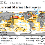
Marine Heat Waves Remain Dominant and Continue Climate Influence
10/16/2024, 2:31 pm EDT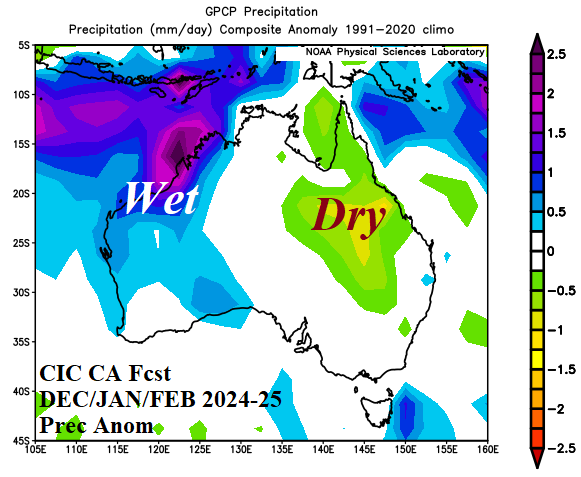
Executive Summary: Climate Impact Company issues the hot season 2024-25 forecast for Australia. Meteorological summer brings suppressed heat risk across the western third of the continent while central and eastern Australia are hotter than normal. The precipitation regime is quite wet in the Northwest, near normal on the South Coast, and drier than normal from central New South Wales across much of Queensland. Summer drought risk during summer 2024-25 increases in Queensland to Northern New South Wales. The forecast is based on a weak and brief La Nina and negative phase Indian Ocean dipole and presence of strengthening marine heat waves either side of the continent.
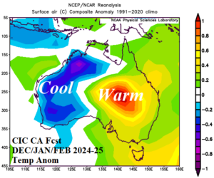
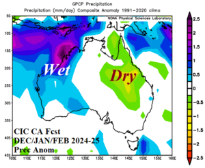
Fig. 1-2: The Climate Impact Company constructed analog temperature and precipitation anomaly forecast for OCT/NOV/DEC 2024.
Climate discussion: The summer 2024-25 outlook valid NOV-24 through MAR-25 for Australia is issued. The forecast is based on a constructed analog using similar past weather patterns best correlated to regional SSTA patterns including El Nino southern oscillation (ENSO), Indian Ocean dipole (IOD), and marine heat waves (MHW). Part of the analog forecast also considers the current continental soil moisture regime and trend.
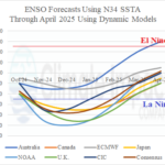
- El Nino southern oscillation: Climate diagnostics indicate marginal La Nina conditions are trying to develop. The Nino34 SSTA has (barely) eclipsed the -0.50C La Nina threshold, southern oscillation index (SOI) is weak positive (supporting stronger than normal trade winds) and forecast to persist, and the subsurface upper ocean heat is weak to moderate cool but enough to initiate La Nina. Dynamic models plus the Climate Impact Company constructed analog produce a consensus forecast of weak and brief La Nina ahead ( 3).
- Indian Ocean dipole: The daily IOD index has produced a sudden moderate negative phase (-0.6) well within the negative IOD threshold. All dynamic model global SSTA forecasts indicate at least a weak -IOD ahead to close 2024 ( 4). Similar with La Nina, the -IOD event is weak and brief. The IOD caveat forecast is quick easing of the current -IOD spike settling to neutral phase ahead (Fig. 5).
- Marine heat waves: Presence of MHW’s has become persistent during the past 1-2 decades. MHW’s can influence traditional ENSO and IOD climate patterns although exact influences are in an ongoing research project. Currently, a MHW has formed northwest of Australia. The MHW appears to be strengthening most notably off the West Coast of Australia. Waters in this region are considerably warmer than 12 months ago. The MHW is supportive of -IOD development. East of Australia, a broad warm SSTA pattern exists and extends well east of New Zealand. Global SSTA forecasts are agreeable that a re-emerging MHW will stretch across the subtropical South Pacific from the East Coast of Australia almost reaching Chile during summer 2024-25. The MHW’s are stronger than ENSO and IOD SSTA regimes and a leading contributor to the Australia summer climate pattern.
- Australia soil moisture: Soil moisture deficit is moderate to strong supporting presence of drought on much of the South Coast and Northwest Coast ( 6). Parts of interior Queensland are also very dry. Marginal dryness is present in parts of eastern New South Wales. The dryness is each region of Australia listed is strengthening.
- Optimum climate normal: The tendency for warming of the subtropical and mid-latitude southern hemisphere oceans is a relatively new phenomenon and notable during the past 5-6 years therefore recent climate influences are added to the analogs to produce the final forecast.
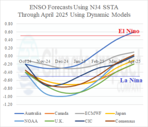
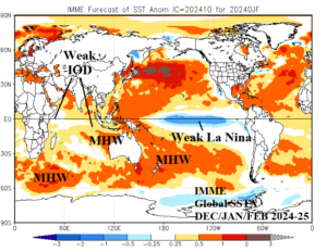
Fig. 3-4: All dynamic models plus the Climate Impact Company constructed analog Nino34 SSTA forecast through April 2025 indicates a short La Nina ahead. The IMME global SSTA forecast for DEC/JAN/FEB 2024-25 identifies IOD, ENSO, and MHW regimes.
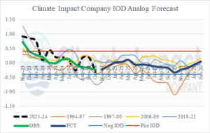
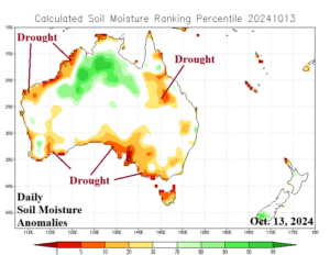
Fig. 5-6: The Climate Impact Company IOD analog forecast doubts negative phase and the daily soil moisture anomaly observations across Australia identify current drought areas.
Forecast methodology: The regional SSTA regimes defined, their trend, and projection through the summer season are used to generate past similar conditions and their attendant weather patterns to make the Australia summer forecast. The most heavily relied upon global SSTA forecasts are ECMWF and the International Multi-model Ensemble (IMME).
November 2024: The projected upper air pattern in November features an upper trough on the Queensland Coast and amplified ridge well southeast of Australia ridging northwestward into New South Wales. The upper trough brings wet weather to the Queensland Coast with suppressed heat risk across East-central continent. The North Coast is wetter than normal and marginally hotter than normal. Southeast Australia is hotter than normal, particularly Victoria. Drier than normal climate is prevalent in northeast and southeast New South Wales. Western Australia is slightly hotter than normal.
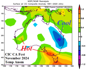
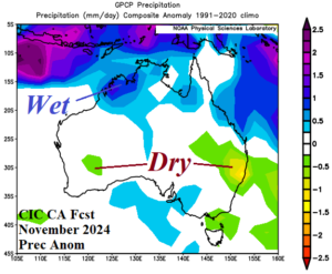
Fig. 7-8: The Climate Impact Company constructed analog temperature and precipitation anomaly climate forecasts for November 2024.
December 2024: As meteorological summer arrives, an amplified upper trough becomes semi-permanent just off the South Coast of Australia. The upper trough causes above normal rainfall in Victoria and the northeast coast of New South Wales. Temperatures will average near normal for the South Coast except marginally hotter than normal for the coastal southeast. The upper trough causes suppressed heat risk across the southwest continent. The North Coast flips drier than normal and therefore hotter than normal. For the second consecutive month, the coastal northwest is wetter than normal.
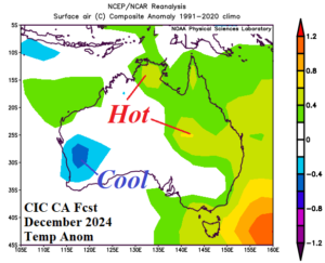
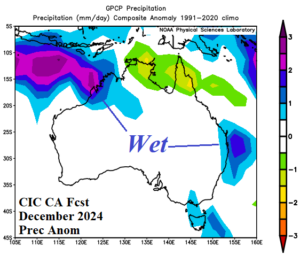
Fig. 9-10: The preliminary Climate Impact Company constructed analog temperature and precipitation anomaly climate forecasts for December 2024.
January 2025: The mid-summer upper air pattern fins and amplified upper ridge over Southeast Australia compensated for by a deep trough on the Northwest Coast. The sensible weather is hot across the southeast quadrant of the continent particularly interior New South Wales. Dryness is likely to accompany the heat. The northwest continent is cooler and wetter than normal during mid-summer.
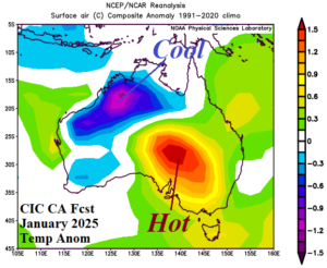
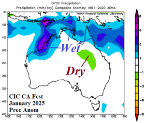
Fig. 11-12: The preliminary Climate Impact Company constructed analog temperature and precipitation anomaly climate forecasts for January 2025.
February 2025: In February, the upper ridge is less amplified but remains over Southeast Australia while the compensating upper trough stays amplified on the West Coast. All Eastern Australia is hotter and drier than normal to close meteorological summer. The western third of the continent is not as hot as normal with above average rainfall.
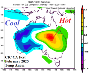
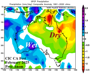
Fig. 13-14: The preliminary Climate Impact Company constructed analog temperature and precipitation anomaly climate forecasts for February 2025.
March 2025: The upper air pattern in March features a wet upper trough affecting Northern Australia with the attendant anomalous rains extending to the Australia East Coast. Except for the North Coast, most of the continent is hotter than normal in March.
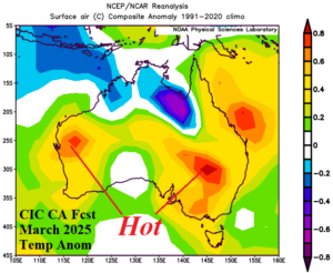
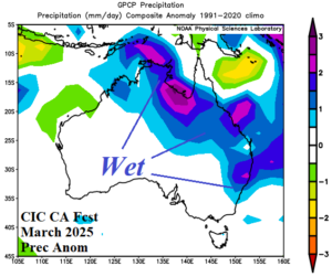
Fig. 15-16: The preliminary Climate Impact Company constructed analog temperature and precipitation anomaly climate forecasts for March 2025.