U.S. Energy Market Early Notes
06/13/2024, 9:31 am EDTU.S. Population Weight JUN/JUL/AUG 2024 Forecast Roars to 4th Hottest of This Century
06/20/2024, 5:48 am EDTExecutive Summary: The Australia season 1-4 ahead outlook is updated. The forecast is valid for JUN/JUL/AUG 2024 through MAR/APR/MAY 2025. Primary governing factors are an anticipated shift of ENSO into La Nina later this year while at the same time, a negative Indian Ocean dipole (-IOD) develops. The pattern is reminiscent of the regime in-place earlier this decade featuring wet weather across Australia. The new outlook doubts significant cold this winter season and is followed by a wet regime developing in the East for springtime.
Climate 2024-25 outlook: Entering meteorological winter 2024, the Australia soil moisture regime features widespread wet conditions most concentrated across the north, central, and east continent (Fig. 1). Drought is harsh on the South Coast and affects some agricultural zones in the far southwest continent and Victoria. The general wetter than normal climate causing mostly wet soil conditions is attributed to deceleration El Nino and positive phase Indian Ocean dipole (+IOD) climate. Both ENSO and IOD are neutral. During winter, the southern annular mode (SAM) or Antarctic oscillation (AAO) has tendency to dominate Australia climate. Currently, a -AAO pattern has helped to induce an upper trough over East Australia compensated upstream by a ridge over West Australia. AAO flips to positive phase to wipe-out the eastern trough in the 8-14/11-15-day period. A fluctuating AAO pattern will continue through the winter season.
The SSTA pattern features widespread anomalous warmth surrounding Australia. Consequently, the winter pattern will average warmer than normal. IOD and ENSO are neutral, but the Indian Ocean tropics is very warm and despite an effort by ENSO to shift toward La Nina, much of the tropical Pacific is also warm. Of course, marine heat waves (MHW) are dominant southwest of the continent and near and east of New Zealand. MHW’s are having a significant influence on Australia moder-day climate.
The North America multi-model ensemble (NMME) global SSTA forecast for late this year into early 2025 (NOV/DEC/JAN) features a developed La Nina, an evolving -IOD pattern, and presence of MHW’s south and east of Australia (Fig. 2). The pattern is reminiscent of the regime in-place earlier this decade suggesting a wet climate pattern ahead heading toward next summer. The La Nina and -IOD pattern are forecast with near normal forecast confidence. Increasing confidence of this regime would produce a wetter climate than indicated in this report.
The drought risk for summer 2024-25 indicates East Australia avoids drought while southern areas should improve.
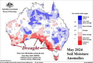
Fig. 1: The May 2024 soil moisture anomaly analysis across Australia.
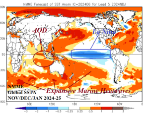
Fig. 2: The NMME global SSTA forecast for NOV/DEC/JAN 2024-25 with annotated areas of prominent influence on Australia climate.
Forecast methodology: The Australia season 1-4 ahead climate forecast is based on a constructed analog. The JUN/JUL/AUG and SEP/OCT/NOV outlooks are based on previous years when ENSO and IOD were neutral and transitioning toward negative phase with presence of MHW’s. The summer and spring 2024-25 outlooks are based on continued presence of MHW’s and negative phase of ENSO and IOD.
JUN/JUL/AUG 2024: The winter outlook becomes less aggressive on the chilly tendency in Southeast Australia. Other probability models maintain this risk. The outlook is warmer with much of the warmth concentrated across northern areas during JUN/JUL and shifting into the Southeast during AUG. The CIC-CA precipitation forecast was benign, i.e. no significant anomalies. Therefore, the CIC-CA outlook projects relative humidity at 1000 MB which identifies a wet risk on the South Coast and Southeast Australia and a dry bias to the north.
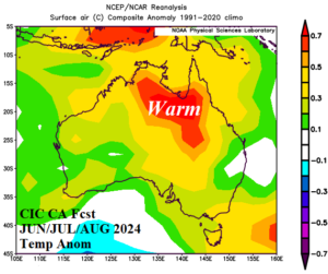
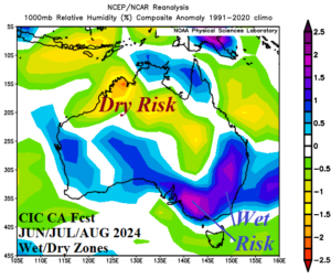
Fig. 3-4: The Climate Impact Company constructed analog temperature and precipitation anomaly climate forecasts for JUN/JUL/AUG 2024.
SEP/OCT/NOV 2024: The spring season indicates a widespread wet pattern in the East as the atmosphere transitions into a La Nina/-IOD climate by late period. The forecast is not as cool as the previous outlook. Anomalous cool climate is projected for Western Australia where the semi-permanent upper trough position is located. A warm tendency is confined to the northeast and southeast continent.
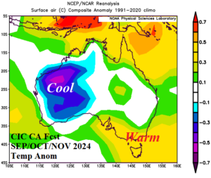
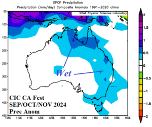
Fig. 5-6: The Climate Impact Company constructed analog temperature and precipitation anomaly climate forecasts for SEP/OCT/NOV 2024.
DEC/JAN/FEB 2024-25: La Nina and -IOD presence next summer season defeat hot climate risk except across the northeast quadrant of the continent and the West Coast. The central and east portion of Australia observes a cooler than normal summer season. The rainfall outlook features potential prohibitive rainfall on the East Coast and is drier than normal across northern areas due to a weak monsoon.
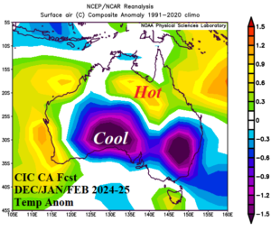
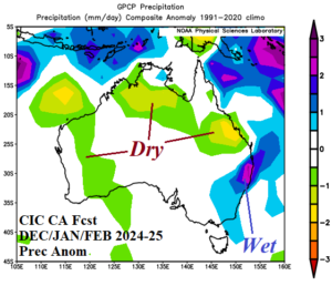
Fig. 7-8: The Climate Impact Company constructed analog temperature and precipitation anomaly climate forecasts for DEC/JAN/FEB 2024-25.
MAR/APR/MAY 2025: Autumn 2025 is soaking wet in the East. The wet weather risk is reminiscent of the wet climate in this zone earlier this decade due to the La Nina and -IOD influence., Only northwest continent is warmer and drier than normal.
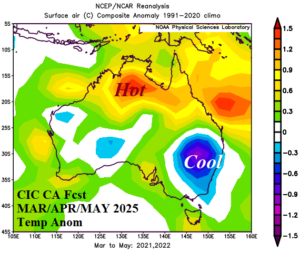
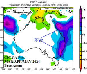
Fig. 9-10: The Climate Impact Company constructed analog temperature and precipitation anomaly climate forecasts for MAR/APR/MAY 2025.