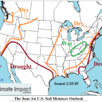
Dry-to-Drought Soil Conditions Cause Potential Excessive Heat Southwest & Central U.S. Summer 2025
02/25/2025, 4:38 pm EST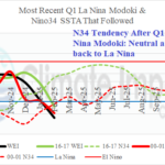
La Nina Modoki Analogs
03/03/2025, 12:59 pm EST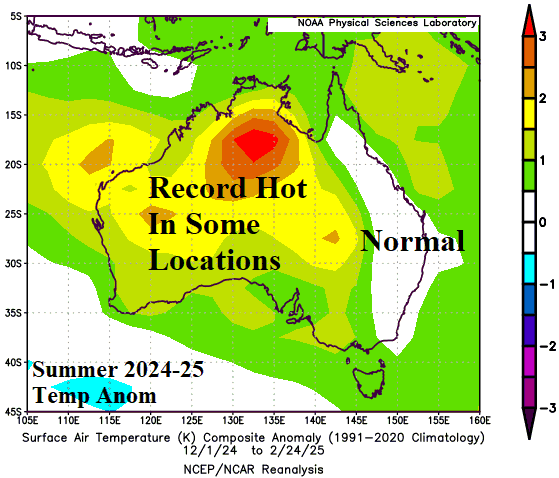
Executive Summary: The Climate Impact Company Month 1-4 Ahead climate forecasts for Australia is updated. The forecast is based primarily on the influence of anomalous warm SSTA surrounding Australia. Forecast models indicate some of the warming is record-strength. ENSO is shifting out of La Nina and possibly toward weak El Nino by mid-winter. The Indian Ocean dipole will stay neutral. Autumn 2025 climate forecast highlights include a wetter than normal pattern across the East which is opposite the drier than normal regime forecast for Queensland by Australia Bureau of Meteorology. The autumn forecast is likely warmer than indicated across west and north continent.

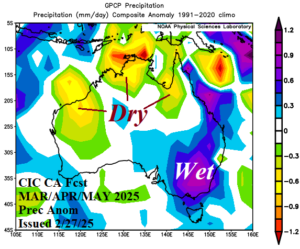
Fig. 1-2: The Climate Impact Company constructed analog temperature and precipitation anomaly forecast for MAR/APR/MAY 2025.
Climate discussion: The meteorological summer 2024-25 season was very hot, record hot in some locations, across most of Australia except near normal on the East Coast (Fig. 3). North/North-central Australia was drier than normal due to a delayed and weak monsoon (Fig. 4). However, due in-part to tropical rains, above normal rainfall was observed in parts of the northwest continent and much of the East Coast. The summer climate was hotter than forecast by Climate Impact Company across the southern tier of the continent (Fig. 5). However, thematically, the Climate Impact Company precipitation forecast was reasonable and focused on wet climate in the East (Fig. 6). The summer 2024-25 climate was governed mostly by the presence of an amplified subtropical high-pressure area across western continent (Fig. 7). The strength of the high pressure was enhanced by the influence of a large and potent marine heat wave (MHW) off the Australia West Coast. The upper air pattern was surprisingly quite different from the 10-year optimum climate normal (OCN) which consistently produces large areas of high pressure near and south of MHW’s southwest of Australia and near New Zealand (Fig. 8). Weak low pressure across Australia during summertime during the past decade is typical replaced by strong high pressure (and attendant heat) during this past summer. Soil moisture conditions are reflective of the rainfall AND temperature regime. Dry soil areas are common across much of the continent except the Northwest and Coastal Queensland (Fig. 9). The ECMWF global SSTA forecast for July, just beyond the scope of the month 1-4 outlook, reveals potential for weak El Nino (Fig. 10). Given the warming of the far eastern equatorial Pacific during late meteorological summer, the ECMWF global SSTA projection is shown as all other models maintain weak La Nina or neutral ENSO. The ENSO forecast for mid-to-late 2025 is generated with below average confidence. Governing the Australia climate into the winter season will be the much warmer than normal ocean surface surrounding Australia.
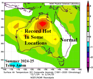
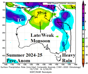
Fig. 3-4: The preliminary meteorological summer 2024-25 temperature and precipitation anomalies across Australia.
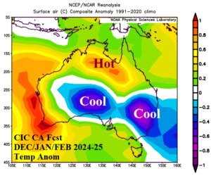

Fig. 5-6: The Climate Impact Company constructed analog summertime temperature and precipitation anomaly forecast for Australia.
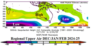
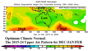
Fig. 7-8: The prevailing upper air pattern across Australia and vicinity compared to the 10-year optimum climate normal. Observations versus OCN were nearly entirely out of phase.
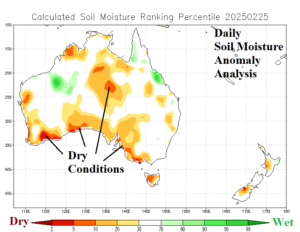
Fig. 9: NOAA/CPC daily soil moisture anomaly analysis reveals dryness for much of Australia.
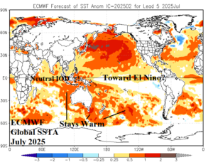
Fig. 10: The ECMWF July 2025 global SSTA forecast is shown due to the potential weak El Nino formation solution uniquely presented by this model.
March 2025: The constructed analog projects an upper trough across the South Coast during early autumn. The upper trough supports a (very) wet climate on the East Coast which may include tropical cyclone strikes. Drier than normal climate persists on the North Coast with anomalous warmth likely stronger than indicated across Western Australia.
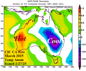
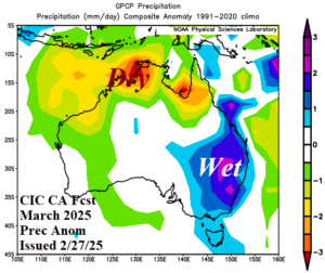
Fig. 11-12: The Climate Impact Company constructed analog temperature and precipitation anomaly climate forecasts for March 2025.
April 2025: During April, an upper trough is forecast to reside south of Tasmania. To the north, patchy wet weather persists on the Queensland Coast and due to the warmer than normal SSTA, late season tropical systems are possible. The upper trough causes cool/wet conditions in Southeast Australia. Western Australia averages drier and warmer than normal, likely warmer than indicated.
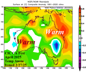
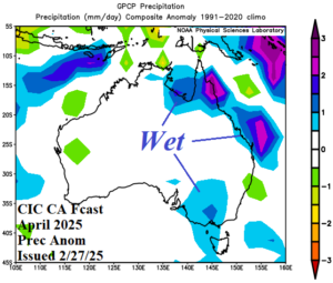
Fig. 13-14: The Climate Impact Company constructed analog temperature and precipitation anomaly climate forecasts for April 2025.
May 2025: The constructed analog maintains the upper trough pattern near the South Coast of Australia. The sensible weather shifts wetter on the West Coast while Queensland to northern New South Wales is notably drier. The Southeast Coast is a wet zone.
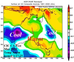
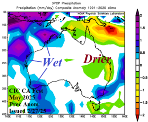
Fig. 15-16: The Climate Impact Company constructed analog temperature and precipitation anomaly climate forecasts for May 2025.
June 2025: The early meteorological winter outlook does not produce an upper air pattern supporting early season cold risk.
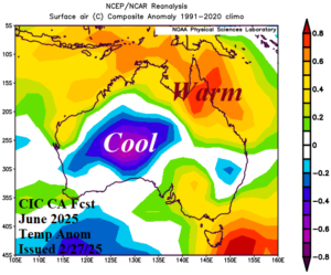
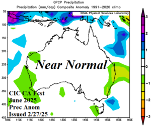
Fig. 17-18: The Climate Impact Company constructed analog temperature and precipitation anomaly climate forecasts for June 2025. Previous below.