Major Excessive Rainfall and Flooding Episode for Southeast/East U.S. Ahead!
08/04/2024, 7:45 am EDTSouth-central U.S. Drought Concern
08/07/2024, 5:01 pm EDTExecutive summary: Climate diagnostics continue to indicate lack of a push toward La Nina. In July, the southern oscillation index was in a weak El Nino phase for the second consecutive month while subsurface upper ocean heat is only marginally cool. Using analogs, the ENSO forecast for the remainder of 2024 and possibly 2025 is neutral phase.
Discussion: The climate diagnostics regarding ENSO during July are mixed. The result is a less-than-convincing trend toward La Nina. ENSO analogs reveal two scenarios for the remainder of 2024 through 2025: 1.) Strong La Nina or 2.) Neutral ENSO. Using a 12-month regression of the Nino34 SSTA, the best fit analogs reveal current observations most closely resemble the neutral phase ENSO ahead scenarios (Fig. 1). The analogs indicate if La Nina were to develop, entry into La Nina phase would have already emerged. Using a 4-year regression due to the relatively unique presence of a 3-year La Nina from 2020-22, the same analogs reveal the 1954-60 ENSO regime is the best fit also indicating neutral ENSO ahead (Fig. 2). A collection of Nino34 SSTA forecast models reveal similarity with the ENSO phase outlook for December 2024. 5 of 7 models indicate La Nina with NOAA strongest while ECMWF and POAMA keep ENSO in neutral phase (Fig. 3). The total analog from CIC indicates weak La Nina and the best fit analogs depict neutral ENSO.
The southern oscillation index (SOI) was in the weak negative (El Nino) range for the second consecutive month in July (Fig. 4). Implied is that the tropical atmosphere is lingering in El Nino phase which may explain why the ocean cooling trend required to initiate La Nina is slow. Normally, 2-3 months of positive phase SOI is required to initiate and sustain trade winds to up-well cool surface water causing La Nina to form.
In the subsurface, a relatively robust cool anomaly which was present last April signaling La Nina ahead has weakened (Fig. 5). A much stronger cool anomaly in the eastern half of the equatorial Pacific is required to help produce an ENSO phase change to La Nina.
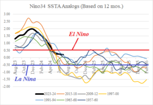
Fig. 1: The Climate Impact Company 12-month regression Nino34 SSTA analog forecast to determine ENSO phase.
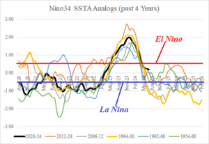
Fig. 2: The Climate Impact Company 4-year regression Nino34 SSTA analog forecast to determine ENSO phase.
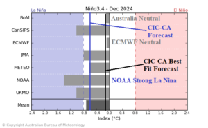
Fig. 3: A collection of dynamic models forecast ENSO phase for December 2024 and the CIC-CA (all years) analog and (best fit years) analog.
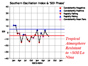
Fig. 4: The monthly southern oscillation index (SOI) is not shifting to positive phase which is required to initiate an ENSO phase change to La Nina.
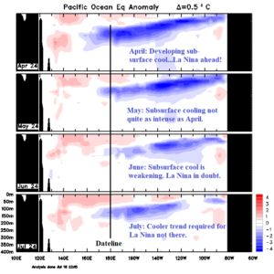
Fig. 5: The Australia Bureau of Meteorology subsurface equatorial upper ocean heat anomalies for the past 4 months.