UPDATED North Atlantic Basin 2024 Tropical Season Outlook…Still Very Active SEP/OCT/NOV
08/27/2024, 8:04 am EDTDry/Hot Pattern Accelerating East Europe/West Russia Drought SLOWLY Fades in September
08/29/2024, 3:51 am EDT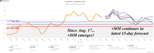
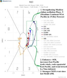
Fig. 1-2: For the first time since El Nino ended earlier this year, a sustained La Nina-like southern oscillation index has formed. The +SOI is enhanced by the presence of the convection phase of the Madden Julian oscillation forecast to strengthen across Maritime Continent.
Discussion: During the past 3 weeks, the southern oscillation index (SOI) has shifted into a very La Nina-like strong positive phase. The 15-day operational forecast maintains +SOI (Fig. 1). The lengthy period of +SOI is sustained by emergence of the convection phase of the Madden Julian oscillation (MJO) expansive from the northern hemisphere tropical Indian Ocean and across Maritime Continent to the West Pacific (Fig. 2). Much of this region has turned very wet due to the emerging MJO while to the south, in the subtropical southern hemisphere, amplified high pressure has caused unusual heat in Australia. The persistent +SOI, enhanced by MJO, is causing eastern equatorial Pacific trade winds to increase. Subsurface cool waters in the equatorial Pacific are beginning to up-well to the surface. The Nino34 SSTA is now -0.13C after dropping 0.27C during the past 7 days (Fig. 3). Additional Nino34 SSTA cooling is likely while +SOI stays intact. The La Nina threshold is -0.5C.
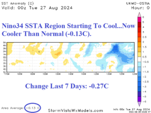
Fig. 3: The Nino34 SSTA has (finally) cooled to below normal during the past week.
The torrid heat across Australia is caused by the amplified MJO signal in the northern hemisphere tropics. The titanic upper ridge remains in the forecast through the next 2 weeks as the Australian heat (and dryness) continues (Fig. 4-5) while just south of the continent, a vigorous storm track is maintained.
Farther downstream, the compensating subsidence phase of the MJO is keeping much of South America much warmer and drier than normal (Fig. 6-7).
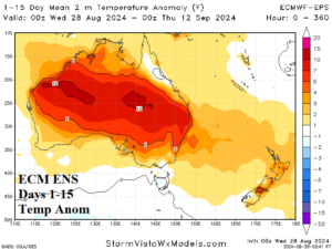
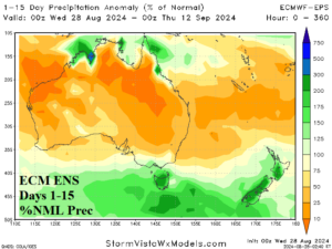
Fig. 4-5: The ECM ENS 15-day temperature and precipitation anomaly forecast across Australia.
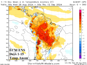
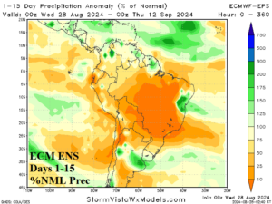
Fig. 6-7: The ECM ENS 15-day temperature and precipitation anomaly forecast across South America.