Lowering Mississippi River to Receive Beneficial Rains
10/30/2024, 5:23 am EDT
Tropical Cyclone Threatens Gulf of Mexico Later This Week
11/03/2024, 1:33 pm ESTHighlight: The Valencia, Spain floods.
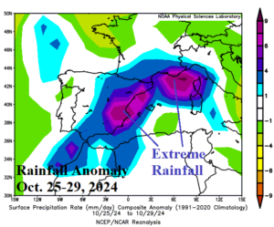
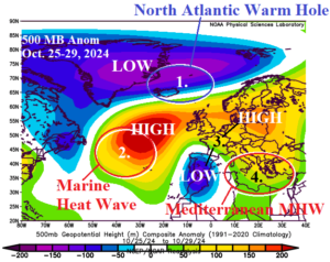
Fig. 1-2: The extreme rainfall across Spain of Oct. 25-29, 2024, and the upper air pattern for the same time-period.
Discussion: As of 5:30AM EDT, Reuters reports 158 deaths associated with series of flash flood events centered on Valencia on the East Coast of Spain. The extreme rain (Fig. 1) began earlier this week, and additional rainfall is forecast over the weekend. The cause of this extreme weather event is related to the prevailing sea surface temperature anomaly (SSTA) pattern across the North Atlantic.
The North Atlantic warm hole (NAHW), an area of cooler than normal ocean water surrounded by the prevailing warmth of recent decades throughout the North Atlantic basin, shifted to waters near Iceland during the 2024 warm season. Aloft, the cooler atmosphere allows an upper trough to form which expanded across Greenland during late October (Fig. 2). To the south, an amplified high-pressure ridge formed over a marine heat wave (MHW) moving from the Northwest Africa Coast in 2023-24 to the central North Atlantic in recent months.
To compensate for these two amplified upper air patterns, a downstream trough formed in late October over Southwest Europe with another upper ridge farther east in West-central Russia. The high-pressure areas blocked the Southwest Europe trough from moving eastward and consequently a potent storm formed over Spain.
Adding to the problem is the increased available moisture in the lower atmosphere of the anomalous warm Mediterranean Sea (due to another marine heat wave) entrained into the low-pressure area to cause the unusually high rainfall amount.
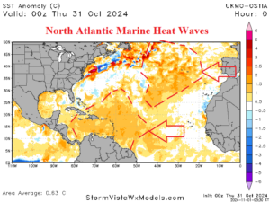
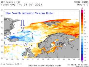
Fig. 3-4: Tracking North Atlantic marine heat waves and the North Atlantic warm hole.

