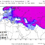
Bare Ground Areas in Southwest Russia Encounter Dangerous Cold Ahead!
01/31/2025, 9:25 am EST
Tracking Winter Weather Events in the East
02/05/2025, 12:57 pm EST
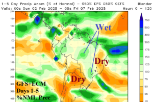
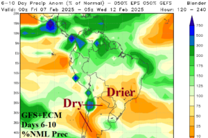
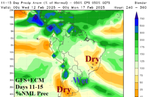
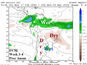
Fig. 1-4: The GFS+ECM percent of normal rainfall forecast during the next 15 days and ECM week 3-4 precipitation anomaly outlook for South America.
Discussion: Combining GFS and ECM percent of normal precipitation forecasts for South America through the next 15 days indicates periodic significant rainfall. In the 1-5-day period, central and southeast Brazil observe heavy rain risk while wet weather also affects a small section of Northeast Argentina near the Uruguay border (Fig. 1). In the 6-10-day period, most of the Argentina and Brazil crop areas are drier than normal (Fig. 2). The GFS+ECM lingers some wet weather in northeastern Argentina in the 6-10-day period. In the 11-15-day period, the GFS and ECM combine to produce heavy rain centered on Uruguay extending to Northern Argentina (Fig. 3). Central Argentina and East Brazil are dry in the 11-15-day period. In the extended period, central and eastern Brazil are drier than normal and to a lesser extent, drier than normal weather affects western and southern Argentina (Fig. 4). The late January rainfall pattern across South America is generally drier than normal across much of Brazil although trending wetter in recent days while patchy heavy thunderstorms have affected Argentina (Fig. 5). Despite some periodic rainfall, much of Brazil is suffering from drought (Fig. 6). Argentina soil conditions are trending drier. Anomalous heat accelerates drying soil conditions. During mid-summer, the hottest anomalies were across Argentina, Paraguay, and eastern Brazil (Fig. 7). The AI Graph Cast ECM ENS 15-day temperature anomaly forecast for South America maintains the anomalous heat across Argentina (Fig. 8).
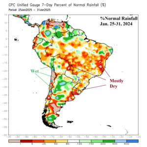
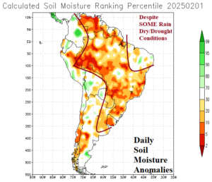
Fig. 5-6:Last week’s percent of normal rainfall and daily soil moisture anomalies across South America.
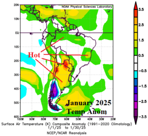
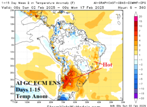
Fig. 7-8: The January 2025 temperature anomalies across South America and AI Graph Cast ECM ENS 15-day temperature anomaly forecast.