Strong Bias/Error by GFS Recent South America Temperature Forecasts
09/27/2023, 8:06 am EDTMidday 12Z GFS Trend is Much Wetter Eastern Half of U.S.
09/29/2023, 1:36 pm EDT


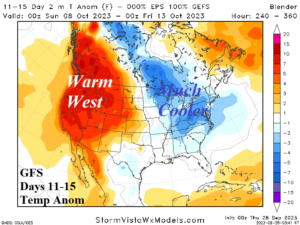
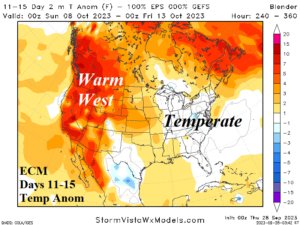
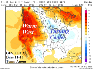
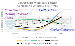
Fig. 1-4: GFS and ECM 11-15-day temperature anomaly forecast (above) and consensus between the two models plus the gas population weight HDD forecast.
Discussion: “If only it were December” was probably a common expression amongst meteorologists, energy traders, and analysts yesterday as the 1200 GMT GFS produced a classic high latitude high pressure blocking pattern to cause a chilly longwave trough to appear in the East U.S. in the 11-15-day period. During the cold season, a dramatic colder pattern change in the 11-15-day period in the high energy demand East U.S. is traditionally the catalyst to a price rise in natural gas. However, early October is a little too early for that scenario, but certainly an attention-getter. Overnight, the (volatile) GFS continues to insist on a cooler pattern change from the Upper Midwest to the Mid-Atlantic States while the warm pattern shifts westward (Fig. 1). To produce this scenario a +PNA/-NAO climate signal forecast should be evident. Overnight climate signals forecasts indicate PNA (NAO) is in the +0.50 to +1.00 (-0.50 to -1.00) range which is “moderate” support. The GFS is a volatile/changeable model BUT very good at recognizing pattern change. While the cold GFS solution in the East U.S. in 11-15 days is overdone, the idea of pattern change is correct. Meanwhile, the more conservative ECM is temperate in the East (Fig. 2). A consensus of both models reveals the cooler trend in the East and the amplifying western warmth (Fig. 3). The natural gas population weight HDD forecast clearly identifies the lack of U.S. heating demand through next week and the increasing demand for Oct. 6-12 biased by the cooler GFS forecast (Fig. 4).
