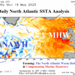
Daily Feature: North Atlantic Warm Hole Forming; Implications?
05/20/2025, 12:24 pm EDT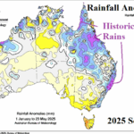
Marine Heatwaves Fueling Historic Australia Rains in 2025
05/23/2025, 5:08 am EDT
![]()
Updated Climate Impact Company 2025 North Atlantic Basin
Tropical Cyclone Outlook
Issued: Wednesday May 21, 2025
Near normal activity in 2025. But! 7 hurricanes indicate a dangerous season.
Executive summary: The updated Climate Impact Company 2025 North Atlantic basin tropical cyclone season forecast projects 16 tropical storms, 7 hurricanes, and 3 intense hurricanes. The accumulative cyclone energy (ACE) index forecast is 137. The outlook is slightly less active than the original outlook issued 2 months ago. The activity forecast is close to the 30-year normal and slightly less active than the 2016-24 active period. The forecast is based primarily on the presence of neutral El Nino southern oscillation (ENSO) and near neutral sea surface temperature anomalies (SSTA) in the deep tropics. Another dangerous season is expected with hurricane strikes for Louisiana and North Carolina, focused on September.
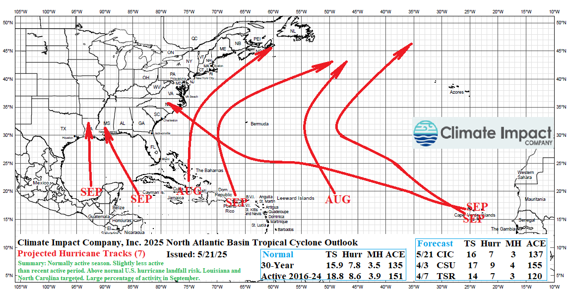
Fig. 1: The updated Climate Impact Company seasonal activity forecast and projected hurricane tracks for the 2025 North Atlantic basin TC season.
Climate: Currently the Nino34 SSTA is normal and has cooled slightly during May. The multivariate ENSO index (MEI) has shifted to neutral phase. Upper ocean heat across the equatorial Pacific Ocean east of the Dateline is slightly warmer than normal. ENSO is firmly in neutral phase. The probabilistic ENSO phase forecast for the remainder of 2025 provided by the International Research Institute (IRI) for Climate and Society strongly favors neutral ENSO through the tropical cyclone season with some upside potential for La Nina regeneration late in the season (Fig. 2). Neutral ENSO favors near to above normal seasonal tropical cyclone activity across the North Atlantic basin.
The International Multi-model Ensemble (IMME) global SSTA forecast for AUG/SEP/OCT 2025 is agreeable with the IRI ENSO outlook. Additionally, the SSTA forecast in the main development region (MDR) for hurricanes is near normal (Fig. 3) and somewhat cooler than recent years. The anomalous warm SSTA across the North Atlantic basin during this time is in the subtropics and northward. Note the Caribbean Sea is normally warm, and the Gulf of Mexico is marginally warmer than normal, both signatures somewhat less warm than recent years. The warm mid-latitude North Atlantic basin implies the presence of stronger than normal high pressure creating dry air enabling sunlight to warm the ocean. South of the high-pressure area, trade winds are stronger than normal up-welling cooler water to the surface preventing the anomalous warm SSTA in the tropics observed in recent years. Implied is the bulk of this year’s activity is strongest north of the tropics.
The upper ocean heat as of mid-May in the MDR (located between the eastern border of the Caribbean Sea and off the coast of Northwest Africa) is the 3rd warmest on record but declining rapidly (Fig. 4). The IMME neutral SSTA forecast in the tropics for AUG/SEP/OCT suggests the upper ocean heat in the MDR for the 2025 tropical cyclone season will not be nearly as warm as the record warmth observed during the past 2 seasons. Once again, the implications are 2025 activity is biased out of the deep tropics and favoring the subtropics and western (North Atlantic) basin.
Last year, strong trade winds pushing dust from the West/Northwest Africa Desert into the tropical North Atlantic suppressing tropical cyclone development during late meteorological summer was associated with Africa drought. This year, the IRI precipitation probability forecast for JUL/AUG/SEP favors a wet regime in the tropics likely to prevent the dust-cloud issue and increase the strength of tropical waves entering the North Atlantic basin once the peak of season arrives (Fig. 5).
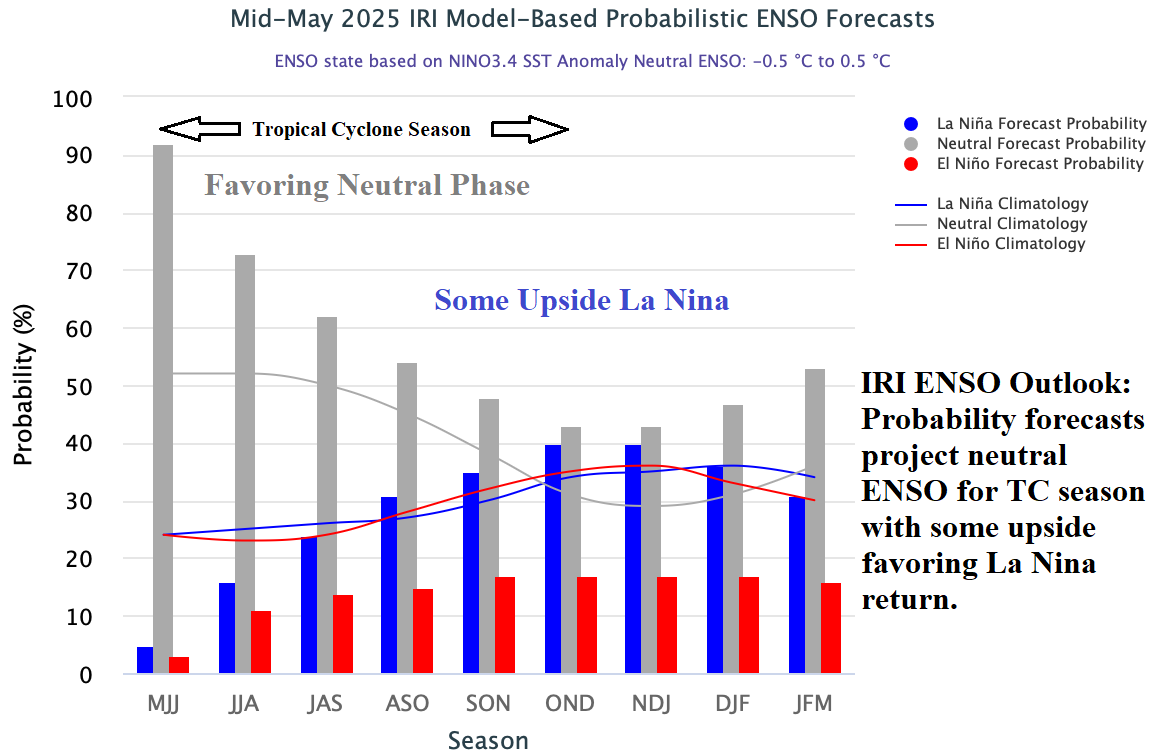
Fig. 2: The ENSO probabilistic forecast from IRI strongly favors the neutral phase for the tropical cyclone season with some upside risk of regenerating La Nina late in the season.
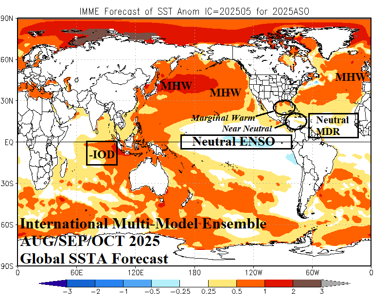
Fig. 3: The International multi-model ensemble global SSTA forecast for AUG/SEP/OCT 2025 identifying key areas influencing 2025 North Atlantic tropical cyclone activity.
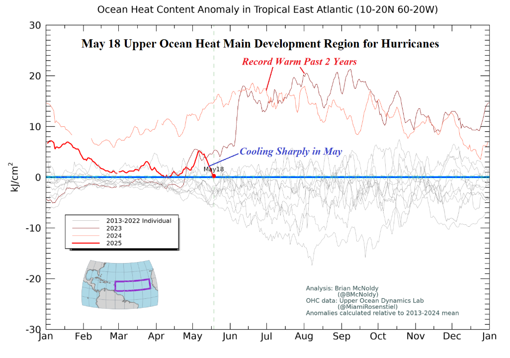
Fig. 4: The upper ocean heat anomalies analysis for mid-May indicates a recent decline in the MDR region.
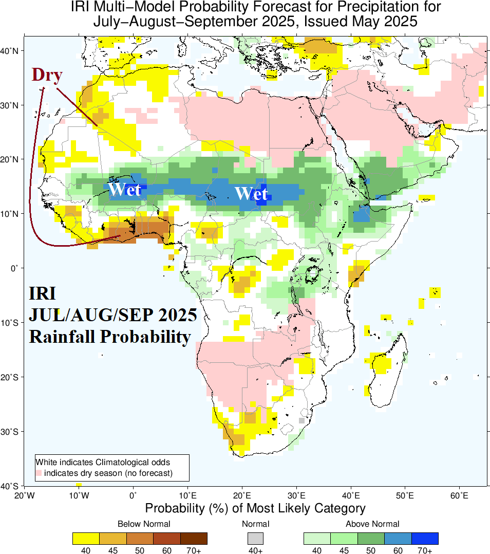
Fig. 5: The IRI precipitation probability forecast for JUL/AUG/SEP 2025.
The 2025 season predictors: The outlook is based analog years most closely associated with the SSTA forecasts previously described focused on neutral ENSO and near normal water temperatures in the North Atlantic tropics. The best analog years are 2016 (weighted twice), 2018, and 2019. The analog years are used to produce a 600 MB relative humidity forecast for AUG/SEP/OCT (Fig. 6) to determine the most likely location for stronger storms during the peak of season. The RH forecast indicates the deep tropics are drier than normal in the mid-troposphere. The dryness strongly suggests that tropical cyclone development and intensification in the deep tropics is below normal risk. However, just north of the tropics, conditions are (more) favorable for development and tracks of storms which identifies the explanation for 2025 hurricanes generating and traveling (mostly) away from the deep tropics. Also note the high RH forecasts for Louisiana and North Carolina suggesting the most likely location for coastal strikes. The RH forecast is not overwhelmingly convincing therefore the “caveat” forecast is less active than forecast.
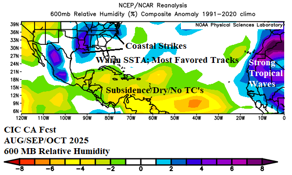
Fig. 6: Climate Impact Company analog forecast of the tropical North Atlantic index located in the main development region for North Atlantic hurricanes
The 2025 season analog forecast: The updated North Atlantic basin 2025 seasonal activity forecast indicates 16 tropical storms, 7 hurricanes, and 3 major hurricanes with an accumulated cyclone energy (ACE) forecast of 137. The outlook is just slightly less active than the original outlook issued 2 months ago. The seasonal activity forecast is very close to the 30-year normal and slightly less active than the 2016-24 active period. However, given the potential for 7 hurricanes, the 2025 season is considered very dangerous.
| Weight | Tropical Storms | Hurricanes | Major Hurricanes | ACE Index | Coastal Strikes | |
| 2016 | 2 | 15 | 7 | 4 | 141 | 4/2/0 |
| 2018 | 1 | 15 | 8 | 2 | 133 | 4/2/1 |
| 2019 | 1 | 18 | 6 | 3 | 132 | 3/2/0 |
| Average | 15.75 | 7.0 | 3.25 | 136.75 | 3.75 | |
| Forecast | 16 | 7 | 3 | 137 | 4/3/1 | |
| Previous | 17 | 7 | 5 | 137 | ||
| 15-Year | 17.9 | 8.1 | 3.5 | 133.6 | ||
| 30-Year | 15.9 | 7.8 | 3.5 | 134.8 | ||
| 50-Year | 13.2 | 6.7 | 2.8 | 108.8 | ||
| 2016-24 | 18.8 | 8.6 | 3.9 | 151.1 |
Table 1: The Climate Impact Company updated 2025 North Atlantic basin tropical cyclone season activity forecast.
The 2025 season projected hurricane tracks: The hurricane track forecast is strongly biased by the analog years and the RH forecast. Notable is the emerging hurricane strength generally north of the deep tropics therefore favoring north-northwest to northeast tracks (Fig. 7). One system is expected to gain long distance traveler status. Hurricanes are focused on September (5 of 7) which is historically the peak of season. The RH forecasts indicate coastal strikes favoring Louisiana and North Carolina. All hurricane coastal strikes occur in September, which is easily the most dangerous month of the season.

Fig. 7: The Climate Impact Company hurricane tracks forecast for the 2025 season.
Other forecasts: The Climate Impact Company 2025 North Atlantic basin seasonal tropical cyclone activity forecast is very close to the 30-year normal. The Colorado State University (CSU) forecast is higher than the 30-year normal and close to the 2016-24 active period climatology. The U.K./Tropical Storm Risk (TSR) forecast is slightly lower than CIC. The TSR and CSU forecast updates are due soon. NOAA/NHC will issue their seasonal probability forecast shortly. The expected consensus of all forecasts is near to slightly above the 30-year normal climatology and slightly above normal risk of hurricanes striking the U.S. Coast.