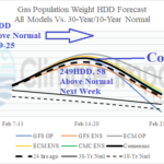
Colder Trend for Next Week in the U.S.; HDD Count Increasing
02/13/2025, 9:01 am EST
NOAA Updates Long-lead Climate Forecasts
02/20/2025, 9:26 am EST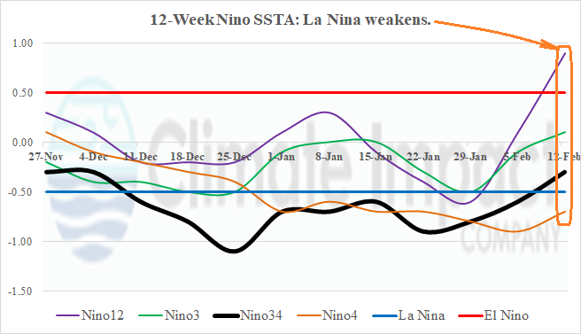
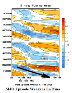
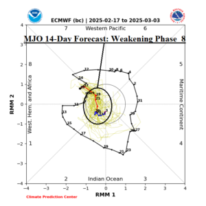
Fig. 1-2: The outgoing longwave radiation anomalies (OLR) identify a recent intense convection phase of the Madden Julian oscillation shifting eastward across the Atlantic tropics and the 14-day (weaker) MJO forecast.
Discussion: The Kentucky flooding and high wind episode across the Mid-Atlantic States was triggered, in part, due to an eastward shifting convection phase of the Madden Julian oscillation (Fig. 1). The presence of this feature forced tropical/subtropical involvement of the weekend storm which produced devastating flooding in Kentucky and widespread power outages in the Mid-Atlantic region due to high wind. The MJO is shifting eastward and weakening entering tropical Africa through late February (Fig. 2). MJO may weaken entirely during early March. Usually, MJO episodes shifting across the eastern equatorial Pacific cause negative southern oscillation index (-SOI). The -SOI response was delayed, showing during the past 5-7 days. When -SOI is present, implied is weaker trade winds and diminished ability to generate up-welling of cool water to the eastern equatorial Pacific. During the past 7-10 days, the effect of the passing MJO event through the tropical East Pacific severely injured the La Nina episode. Most of the Nino SSTA regions are now in neutral phase including warming of the Nino12 region off the northwest coast of South America to an El Nino-like +0.9C last week (Fig. 3).

Fig. 3: The recent MJO event has weakened La Nina based on the warming Nino SSTA observations of the past week.