Australia Heatwave Ahead!
10/25/2024, 11:42 am EDTDoes a Dry/Hot Bias Develop in Eastern Australia Due to IOD/ENSO?
10/29/2024, 5:42 am EDT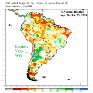
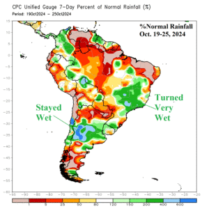
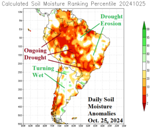
Fig. 1-3: The 30-day and 7-day percent normal rainfall across South America and the daily soil moisture anomaly analysis.
Discussion: During October, Northwest Argentina turned very wet (Fig. 1). During the past week, the wet pattern in Argentina shifted slightly southward and remains intense (Fig. 2). Meanwhile, a separate wet weather pattern has emerged during the past week in Brazil featuring drought suppressing heavy rains from East-central Brazil eastward to the coast. The recent rains have eased drought in parts of East-central and East Brazil while Argentina soils are turning wetter than normal (Fig. 3).
The outlook maintains the wet weather pattern as an upper trough lingers over Southeast Brazil through 10 days. ECM MAXRES identifies moderate to heavy rain from Northwest Argentina through Southwest and East Brazil (Fig. 4). However, in the 11-15-day period, the upper trough shifts off the coast with the northern tail of this feature still able to deliver wet weather shifting into Northeast Brazil (Fig. 5). At that time, Central to Southeast Brazil shifts drier and possibly quite hot.
Both the ECM and CFS V2 maintain wet risk in Brazil in the 16-20-day period.
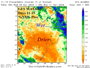

Fig. 4-5: The ECM MAXRES 10-day percent of rainfall outlook across South America and the 11-15-day forecast utilizing GFS MAXRES.
