Much of U.S. Turning Scary Dry First half of October Especially Great Plains
10/01/2024, 8:15 am EDTU.S. Warm and Dry Pattern Continues, Drought Expansion!
10/04/2024, 11:35 am EDT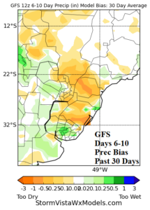
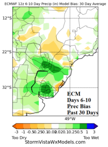
Fig. 1-2: The GFS and ECM rainfall bias during the 6-10-day period for the past 30 days indicates GFS is too dry and ECM is too wet.
Discussion: Rainfall forecast bias by GFS and ECM for Brazil during the past 30 days has on average, been too dry by GFS and too wet by ECM. The errors are quite large (Fig. 1-2). The temperature bias is super-warm by GFS and considerably less warm by ECM (Fig. 3-4). The 6-10-day period is evaluated for the past 30 days.
The forecast error is important when considering the wetter pattern change ahead.
The upper ridge over Brazil breaks down during the medium range. An energetic mid-latitude flow enables cold fronts to push farther north. Frontal systems deliver much needed rain to key crop areas in Brazil most notably in the medium range (Fig. 5-6).
The extended range forecasts by ECM indicate the wetter pattern eases slowly and returning dry weather is biased toward the northern half of Brazil (Fig. 7-8).
Of interest is a developing marine heatwave off the east-southeast coast of Brazil (Fig. 9). The SSTA pattern has warmed dramatically during the past 30 days (Fig. 10). The warming of waters in this region increases the likelihood of an upper-level high pressure ridge pattern for the warm season ahead. Later today, Climate Impact Company will update the months ahead climate forecast.
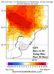
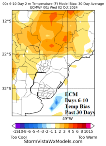
Fig. 3-4: The GFS and ECM temperature forecast bias for the 6-10-day period for the past 30 days reveals the super-warm error by GFS outlooks.
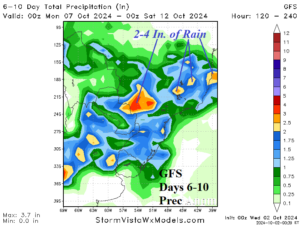
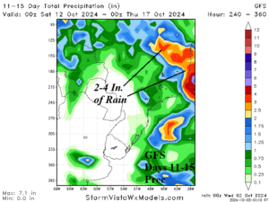
Fig. 5-6: The GFS 6-10-day and 11-15-day rainfall forecast indicates significant amount across major Brazil crop areas.
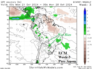
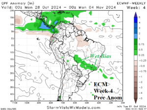
Fig. 7-8: The ECM Week-3 and week-4 ahead rainfall anomaly forecast across South America indicates a wet bias across Southern Brazil.
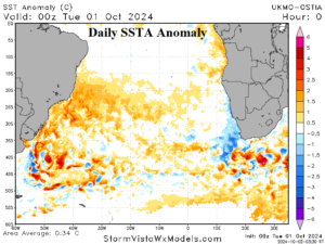
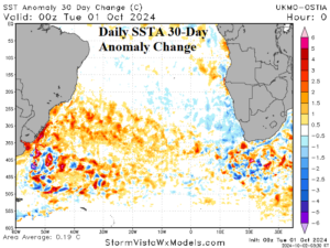
Fig. 9-10: The South Atlantic daily SSTA analysis and 30-day change identifies a developing marine heatwave off the East/Southeast Coast of Brazil.