Nino34 SSTA Reaches La Nina Threshold
09/23/2024, 1:51 pm EDTHelene Likely to Reach Category-4 Major Hurricane Intensity Making Landfall in Northwest Florida
09/26/2024, 5:42 pm EDTCharts of the day: Maintaining neutral IOD ahead & recent rainfall.
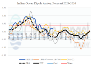
Discussion: Reviewing the 1993-2024 monthly IOD index, positive phase spikes are usually followed by the negative phase. A sharp +IOD was observed in 2023 fading earlier this year. Anticipated (earlier this year) was generation of a new negative phase. However, monthly observations during 2024 reveal a steady neutral phase. Using a JAN-23 to SEP-24 analog, the obvious (analog) years to project a 2024-25 forecast are 1995-96, 1998-99, and 2020-21. The consensus of the analogs is neutral phase ahead with any possible difference later next year when -IOD could emerge.
A wet pattern was observed across northwestern Australia during the week of Sep. 17-23, 2024. Wet weather was also observed in Victoria.
Week-2 Ahead Forecast valid September 29-October 5, 2024: Cooler pattern Central; Wet risk East.
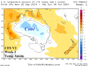
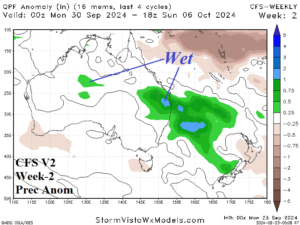
Discussion: Utilizing CFS V2 reveals a cool upper trough in central continent fueling wet weather risk across southeast Queensland/northeast New South Wales. Hot and dry risk is confined to the West Coast.
Week-3 Ahead Forecast valid October 6-12, 2024: Patchy rains; Not a dry pattern.
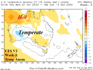
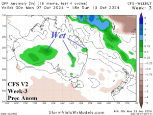
Discussion: Wet risk shifts to the southwest quadrant of the continent. Patchy rain is likely in the East. Only the coastal northwest is hot.
Week-4 Ahead Forecast valid October 13-19, 2024: Wet risk New South Wales.
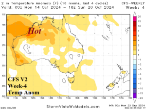
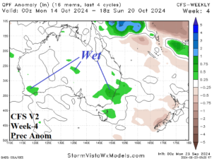
Discussion: Wet risk is across eastern New South Wales while most of the anomalous heat remains in the northwest and southwest portion of Australia.