Possible Carolinas/Mid-Atlantic States Heavy Rain Episode Early Next Week
09/12/2024, 8:54 am EDTCritically Dry Versus Wet Regional Soil Moisture Conditions Across U.S.
09/17/2024, 6:30 am EDT 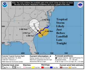
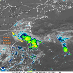
Fig. 1-2: NOAA/NHC forecast track for Potential Tropical Cyclone 8 and the morning weather satellite view.
Discussion: At 5AM EDT Potential Tropical Cyclone 8 was located at 32.4N/78.3W or about 95 miles east-southeast of Charleston, SC. This system is moving northwest at 3 mph with top wind near 50 mph and central pressure 1006 MB. A large mass of heavy thunderstorms is north and east of a low-pressure area off the Carolina Coast. NOAA/NHC claims the low-pressure area is struggling to gain subtropical or tropical storm characteristics. The official forecast is for a tropical storm inland by this evening but whether a named storm emerges or not apparently is uncertain according to NOAA/NHC. USAF reconnaissance aircraft found 54 knot winds northeast of the center. Regardless of whether this system becomes a named storm (Helene is the next name) heavy rain and tropical storm force wind will affect the upper coast of South Carolina and lower coast of North Carolina later today and tonight. This system weakens quickly once inland tonight and Tuesday.
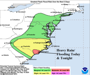
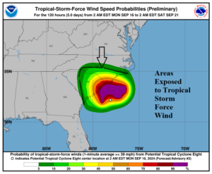
Fig. 3-4: Heavy rain/flood risk area for today and tonight and the area susceptible to tropical storm force wind.