Upper Ridge Pattern Continues Over Northwest Eurasia and Well-Correlated to Norwegian Sea MHW
09/05/2024, 5:12 pm EDTUsing AIFS, Beneficial Rain Southern Brazil Sugarcane Areas Ahead
09/11/2024, 11:03 am EDT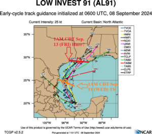
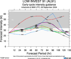
Fig. 1-2: Tropical cyclone models tracks and intensity projections for Tropical Disturbance 91L.
Discussion: A tropical cyclone is likely in the western Gulf of Mexico this week. Tropical cyclone models take Tropical Disturbance 91L from the Bay of Campeche northwestward with gradual development to a tropical storm in 48-72 hours arriving off the northeast coast of Mexico followed by a north-northeast turn and continuing to intensify, possibly to a hurricane, before reaching the northwest Gulf of Mexico Coast Friday morning, most likely in Louisiana (Fig. 1-2). As usual, forecast confidence is low until an actual tropical system develops. Diagnostics reveal a massive amount of thunderstorm activity in a light shear environment. Water temperatures rise to 87F/31C just north of 91L. Potential for faster development and a stronger system than projected is possible. Upper shear across the northwestern Gulf of Mexico is 60 mph. The shear should ease and allow this system to travel north and strengthen. However, the shear pattern is very supportive of the northeast turns into Louisiana late this week. The NOAA/WPC 5-day rainfall forecast indicates 3-7 in. of rain along the Texas Coast on the west side of the storm as it travels north and northeast mid-to-late week (Fig. 3). Areas offshore and eventually Louisiana receive extreme rainfall based on the preliminary forecast track. Many areas in Mexico, Texas, and Louisiana have received heavy rains during the past week (Fig. 4).
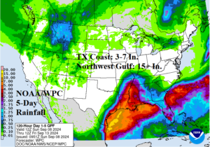
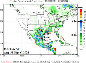
Fig. 3-4: The NOAA/WPC 5-day rainfall forecast for the U.S. and the observed rainfall for Aug. 31-Sep. 6 across the U.S. and Mexico.
This week’s extreme heat risk peaks in Southern California today and Monday where Excessive Heat Warnings are posted. Excessive heat is also occurring across the southern 2/3 of Florida. Excessive heat shifts across the North-central U.S. TUE/WED and continuing THU while advancing to the Ohio Valley. By Friday, unusually hot weather for September reaches New England. The warming of the East follows an unseasonably cool start to the week.
In the medium range, a hurricane forms in the central North Atlantic and turns northward as a “fish storm”. In the U.S., the very warm weather pattern continues in the Central U.S. to central and eastern portions of Canada in the 6-10-day period while the West turns much cooler according to AIFS (Fig. 5). The AIFS has shown the best skill scores in the 11-15-day forecast since mid-summer. Today’s 11-15-day forecast by the AIFS indicates the warm pattern lifts northward to Canada while the U.S. cools toward normal except for regenerating heat in California (Fig. 6).
The U.S. population weight CDD forecast features below normal electricity for air conditioning demand for the current week (Fig. 7). However, cooling demand will increase for mid-to-late September as anomalous heat shifts into parts of the East U.S.
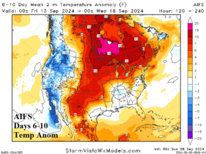
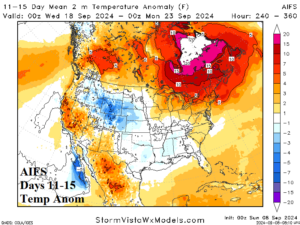
Fig. 5-6: The AIFS 6-10-day/11-15-day temperature anomaly forecast across the U.S.
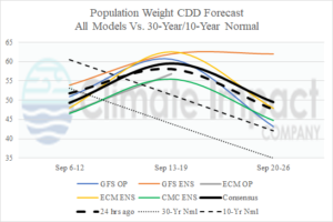
Fig. 7: U.S. population weight CDD forecast utilizing all models, their consensus, and comparing with 24 hours ago plus the 30-year/10-year normal.