Deluge of Rain Ahead on the Texas Coast
08/29/2024, 1:37 pm EDTSteady +SOI Supports Trend Toward La Nina
09/02/2024, 10:35 am EDT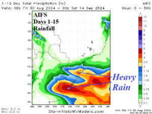
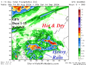
Fig. 1-2: The South America/Argentina and Black Sea region 15-day rainfall forecast.
Discussion: The largest surprise in forecast models is the increase in rainfall in the 15-day outlook for Northeast Argentina, Uruguay, and Southeast Brazil. The AIFS forecasts consistent rains piling to several to 6 inches due to a quasi-stationary frontal boundary in the region (Fig. 1). To the north, Brazil remains hot and dry. Meanwhile, a hot and dry regime persists across Central/East Europe to West-central Russia. However, undercutting the amplified upper ridge producing the late summer heat, an upper low causes pulses of heavy rain in the immediate Black Sea region (Fig. 2). The Europe late summer hot weather pattern eases after 7-10 days (Fig. 3). China has avoided a major drought during the summer season. However, scorching hot weather is forecast through the next 15 days well into September (Fig. 4). In Australia, the unusual late winter season anomalous heat continues (Fig. 5). However, wetter pattern change is in the distant future beginning in the week-3 outlook (Fig. 6).
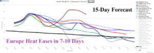
Fig. 3: The Europe System 15-day temperature average forecast compared to the 30-year normal.
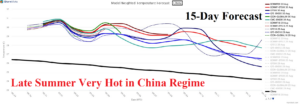
Fig. 4: The China System 15-day temperature average forecast compared to the 30-year normal.
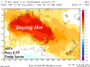
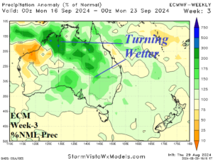
Fig. 5-6: The 15-day temperature anomaly forecast across Australia and the week-3 ahead percent of normal rainfall outlook.