Expanding Europe Heatwave
08/28/2024, 5:07 am EDTSneaky Wet in Northeast Argentina/Southeast Brazil
08/30/2024, 5:56 am EDTHighlight: Plenty to monitor in the North Atlantic basin, extreme rains northwest Gulf, and temperate/cool Central/East 12Z GFS.
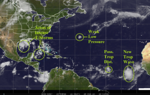
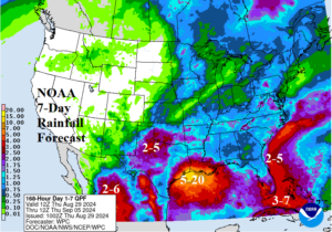
Fig. 1-2: Many areas of thunderstorm activity in the tropical/subtropical North Atlantic basin and the NOAA/WPC 7-day U.S. rainfall forecast.
Discussion: The North Atlantic basin is steadily becoming more interesting regarding potential tropical events (Fig. 1). The outer North Atlantic basin contains 2 possible events developing this weekend. Similarly, the western Gulf of Mexico and northwest Caribbean Sea are convection active. The NOAA/WPC 7-day U.S. rainfall forecast indicates buckets across Northwest Texas, Coastal Texas/Louisiana, and Florida/Coastal Southeast (Fig. 2). The midday 12Z GFS has very similar 6-10-day and 11-15-day forecasts with hot weather across the West and temperate cool Great Plains to the Northeast Corridor (Fig. 3-4).
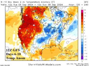
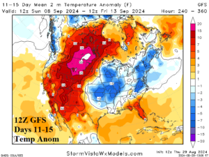
Fig. 3-4: The 12Z GFS medium range temperature anomaly forecast.
| CDD EIA End Date | Forecast | 12-Hour Change | 24-Hour Change | 30-Year Normal | 10-Year Normal |
| 8/29 | 78.7 | -0.1 | -0.1 | 67.8 | 74.5 |
| 9/5 | 65.5 | -3.0 | -4.2 | 61.4 | 68.4 |
| 9/12 | 54.6 | -9.4 | -17.3 | 53.1 | 60.5 |
Table 1: The 12Z GFS U.S. population weight CDD forecast compared to 12 and 24 hours ago.