Wet Pattern Ahead Squashes Texas Heat
07/13/2024, 6:06 am EDTENSO-Neutral, No Sign of La Nina Motivation
07/15/2024, 11:45 am EDTChart of the day: Massive Sahara Dust tracking westward.
Discussion: The North Africa climate pattern of the past 2-3 months is unusually hot and dry. Increasing trade winds south of intensifying subtropical high pressure is pushing Saharan Dust into the tropical/subtropical North Atlantic suppressing tropical cyclone development. Outlooks indicate the Saharan Dust will extend westward to the Caribbean Sea this week with intensity with several surges to follow over the next 15 days. Tropical cyclone risk is greatly diminished.
Week-2 Valid July 21-27, 2024: Tropical rains focused on Texas.
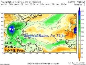
Discussion: Heavy tropical rains not related to tropical cyclones convene on Texas while tropical cyclone risk in the central/east North Atlantic tropics is reduced due to Saharan Dust.
Week 3 Valid July 28-August 3, 2024: Texas stays wet, tropics quiet.
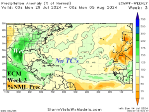
Discussion: The gusty trade winds propelling Saharan Dust across the tropical/subtropical latitudes continues and limits tropical cyclone development into early August.
Week 4 Valid August 4-10, 2024: Tropical cyclone risk present but lowers from previous outlook.
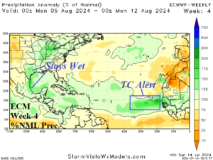
Discussion: A tropical cyclone alert is indicated for the eastern tropics. Tropical cyclone risk in the Caribbean Sea or Gulf of Mexico is diminished from the previous forecast.
Week 5 Valid August 11-17, 2024: Activity increase.
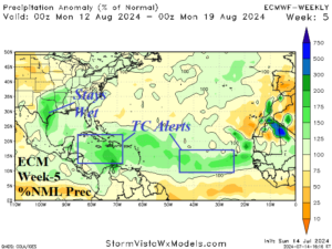
Discussion: The tropics look busy with tropical cyclone risks increasing by mid-August.