South America 2-Week Rainfall Forecast Trending Wetter!
04/10/2025, 4:10 am EDT
Recent Rapid Warming of Nino SSTA Regions Eases
04/15/2025, 5:18 am EDT
Posted on website: U.S. selected cities CDD forecasts for 2025 plus the PJM, ERCOT, and SPP CDD outlooks.


Fig. 1-2: Frigid ocean temperatures off the Northeast Coast bias the coastal climate chilly when wind is onshore. The warm Nino12 SSTA region continues.
Discussion: A cold north to northeast wind has brought rain and snow to New England this weekend thanks to an offshore storm system made colder by the frigid counter-current to the warm Gulf Stream east and southeast of New England (Fig. 1). Likely continued to by the cold Labrador Current, the ocean surface is unusually cold off the Mid-Atlantic States to southeast of Nova Scotia just north of the Gulf Stream which has warmed significantly in recent weeks. The change in ocean temperature over a short distance is propelling strong winds also enhancing storms that pass by causing over-achieving low pressure. This condition may last a while causing a persistent chilly regime on the Northeast Corridor Coastal region when sea breezes are occurring. The New England Coast is affected and adds Long Island and vicinity and extends to New Jersey and Delaware shorelines.
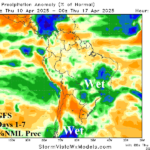
The excessive rainfall episode of early April centered on the Mid-south U.S. was contributed to by the warm SSTA off the southwest coast of South America (Fig. 2). The warm waters added low-level atmosphere moisture entrained northward by a West U.S. upper trough. The waters off the northwest coast of South America have cooled slightly but remain robust. A new convection phase of the Madden Julian oscillation (MJO) is forecast for the 8-14-day period (Fig. 3) in the central equatorial Pacific Ocean which should cause the upper-level pattern to at least partially engage the warm SSTA off South America to propel a wet to very wet 8-14-day period across the Central and East U.S. (Fig. 4).
River flooding is ongoing along the southwest Ohio River to central Mississippi River (Fig. 5). River flooding continues to shift south through April. While this week is mostly dry, wet weather is ahead for next week.
The U.S. medium range temperature anomaly forecast according to the overnight ECM ENS (Fig. 6-7) reveals the western warmth shifting east but with less ferocity compared to outlooks from last week likely due to wetter weather and a cool ocean bias on the Northeast Corridor Coast.


Fig. 3-4: Active phase of the Madden Julian oscillation emerges in the 8-14-day period coinciding with a wetter trend across the Central and East U.S.

Fig. 5: The NOAA/WPC 5-day river flood forecast.
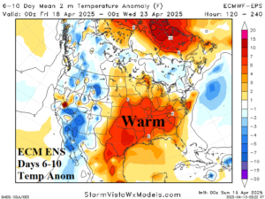
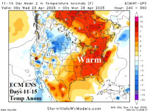
Fig. 6-7: The ECM ENS medium range temperature anomaly forecast for the U.S.