Executive summary: Late spring into early summer produces substantial flooding from extreme rains already occurring in Southern Florida and shifting into Texas later this week extending northward to the Midwest U.S. However, areas north and east of these heavy rain zones have the opposite problem likely to last well into the summer season, lack of significant rain and steady anomalous heat casual to increased drought risk from the Ohio Valley to the Mid-Atlantic States. By late summer, a shift in tropical rains should ease drought in the Ohio/Tennessee Valleys.
Discussion: Soil moisture extremes, a symptom of climate generated by warming mid-latitude oceans, is emerging in the U.S. Currently, U.S. soil moisture anomalies indicate moderate to strong dry signatures in Southern Texas and the Midwest U.S. (Fig. 1). So far in June, the Midwest dry signature has strengthened and spread east to the Mid-Atlantic region while heavy rains have erased southern Florida drought (Fig. 2). The 7-day forecast indicates additional extremes are ahead. The historic Southern Florida rains shift westward and eventually erase the Southern Texas drought (Fig. 3). The western portion of the Midwest U.S. inherits flooding rains from day after day thunderstorms this week. The Southern Texas and western Midwest dry soil signatures reverse to wet conditions due to the flooding rainfall while areas to the east, including the Ohio Valley to the Mid-Atlantic States trend drier with a consistent anomalous hot pattern that accelerates soil moisture drying.
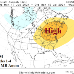
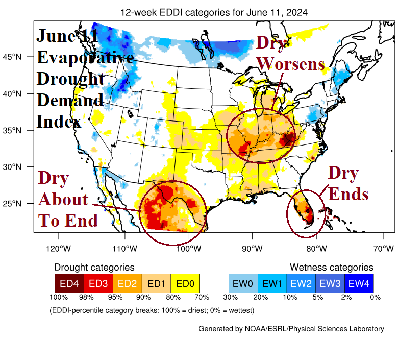
The evaporative drought demand index (EDDI) highlights the Ohio, Missouri, and Tennessee Valley areas with D3/D4 conditions identifying the “thirst” soil conditions have for moisture due to long-term climate and soil conditions in these zones (Fig. 4). The anomalous heat forecast in the 15-day outlook by ECM ENS (Fig. 5) combined with persistent heat and mostly dry climate in the 16-30-day period (Fig. 6-7) according to ECM suggest a drought scare is ahead for mid-summer in these regions while the western and southern boundary of the threat zone is soaking wet.
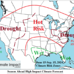
While east of the Gulf States to western Midwest States look very wet and east of this zone trends toward drought, the Interior West U.S. is forecast to observe intensifying drought through the summer season due to a weak (wet) monsoon. NOAA projects harsh drought by September (Fig. 8). The Interior West drought is an excellent source region for anomalous heat to occasionally pulse eastward across the U.S. best-realized in the dry soil region of the Ohio Valley to the Mid-Atlantic States. As the tropical cyclone season becomes active during late summer, some of that rainfall shifts northward and could ease a drought scare for the Ohio and Tennessee Valleys.
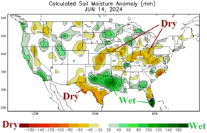
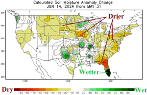
Fig. 1-2: Daily U.S. soil moisture anomalies and the change in June so far.
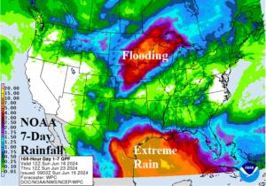
Fig. 3: The NOAA/WPC 7-day rainfall forecast for the U.S.

Fig. 4: The U.S. evaporative drought demand index analysis most recently available on June 11, 2024.
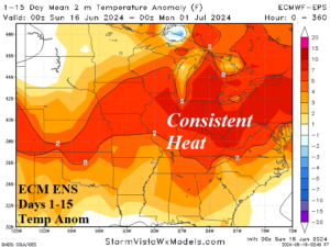
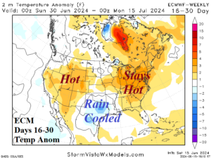
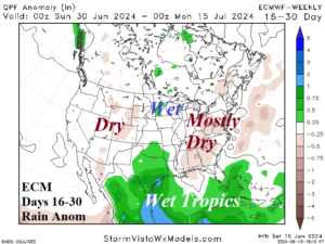
Fig. 5-7: ECM ENS 15-day temperature anomaly forecast across the U.S. AG Belt and ECM 16-30-day temperature and precipitation outlooks.
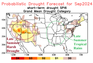
Fig. 8: NOAA SPI6 probabilistic drought forecast for September 2024.