Houston Wednesday Morning Temperature Revised to Frigid Teens (Close to Uri/Elliot Peak Cold)
01/18/2025, 11:12 am EST
Snow Covered Northwest/North Gulf Region Hit By Severe Cold
01/22/2025, 5:48 am EST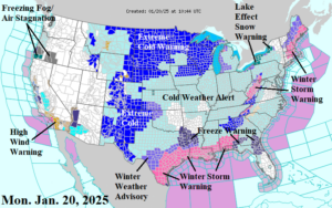
Fig. 1: NOAA/NWS weather watch, warning, and advisory areas.
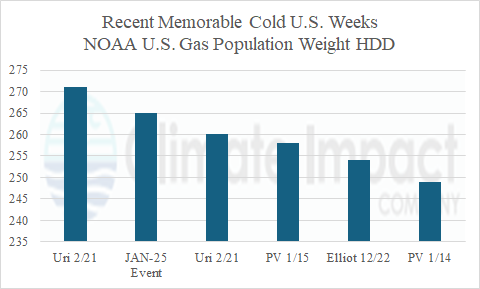
Discussion: The arctic air has spread across the entire U.S. from the Continental Divide eastward excluding central and southern Florida. Winter Storm Warning’s for hefty snows will abate in New England this morning although continue in the Great Lakes region to West Virginia (Fig. 1). Extreme Cold Warnings are issued for the northern and western Great Plains. Bismarck, ND drops to near -20F this morning and tomorrow morning with wind chill near -40F. Amarillo, TX plunges to near zero tonight. Snow, sleet, and ice storm prompts a rare Winter Storm Warning on the entire Texas, Louisiana, Mississippi, and Alabama Coast. NBM forecasts 4-6 inches of snow in Southern Louisiana with 2-4 inches in both the Houston and New Orleans area (Fig. 2). The snowfall/snow cover will enhance the incoming cold and produce widespread subfreezing daytime temperatures Tuesday and teens/low 20’s Tuesday and Wednesday night! Freezing rain/ice accretion is most significant in South-central Texas plus near the GA/FL state line (Fig. 3). This week’s bitter cold produces about 265 U.S. gas population weight heating degree days (HDD). By comparison, this week is second coldest (Fig. 4) compared to recent memorable cold weeks including Cold Weather Event “Uri” from the week of 2/13/21 (260) and 2/20/21 (271), “Elliot” 12/24/22 (254), and polar vortex events from January 2024 (249) and 2015 (258). Another high wind event shifts across Southern California later today, peaking tonight and Tuesday and not ending until Thursday. The latest U.S. gas population weight HDD forecast reveals this week’s cold steadily collapsing heading into a milder February (Fig. 5-6).
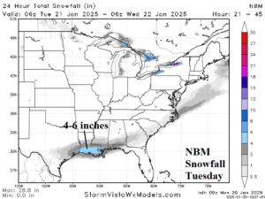
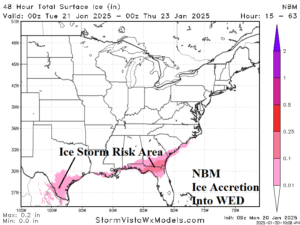
Fig. 2-3: NBM snowfall and ice accretion forecast for Gulf States winter storm.
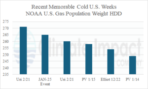
Fig. 4: U.S. gas population weight HDD observations for selected recent cold weeks. By comparison, the current week is the second coldest.
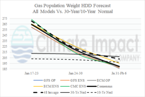
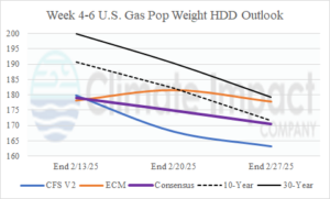
Fig. 5-6: U.S. gas population weight HDD forecast utilizing all models, their consensus, and comparison with 24 hours ago and the 10-year/30-year normal plus the week 4-6 HDD forecast consensus between CFS V2 and ECM.

