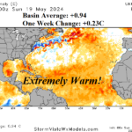
Record Warm Sectors of the North Atlantic Basin Getting Warmer
05/20/2024, 2:23 pm EDT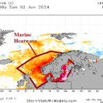
Marine Heat Waves/North Atlantic Warm Hole Climate Causal to Historic Southern Germany Floods
06/04/2024, 2:28 pm EDT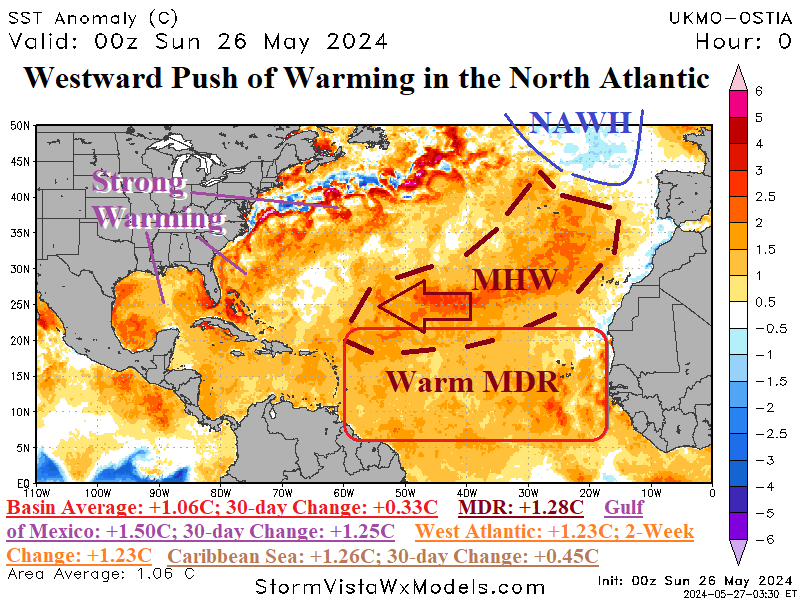
Fig 1: Daily North Atlantic SSTA analysis and regions of importance statistics.
Discussion: Present for nearly 18 months is a large marine heat wave (MHW) off the northwest coast of Africa and southwest of Europe suddenly shifting westward during the past 30 days. The MHW is now separated from the Northwest Africa Coast shifting eastward toward the Sargasso Sea. In-between the eastern Caribbean Sea and west coast of tropical Africa, the main development region (MDR) for North Atlantic hurricanes remains a robust +1.23C although slightly cooler the past 30 days remains the warmest on record for this time of the year. In the Caribbean Sea, the past 30 days have observed a +0.45C warming making the basin a record warm +1.26C for late May. The strongest warming is across the western North Atlantic basin where average SSTA is now +1.23C and all the anomalous warmth has generated during the past 14 days. In the Gulf of Mexico, the basin average has surged to +1.50C with a +1.25C change over the past 30 days. The start of tropical cyclone season is just a few days away and the North Atlantic basin is the warmest on record (+1.06C). The implied upper ocean heat to fuel tropical cyclones is immense. Additionally, the widespread anomalous warmth also indicates sea level rise especially neat the U.S. Coastline. The daily Nino34 SSTA is +0.10C with a 30-day change of -0.54C. Slowly, La Nina will develop over the next 2-3 months. The La Nina climate will lag by one month and be intact by AUG/SEP as the peak of tropical cyclone season arrives. As stated by many forecasters, the immense upper ocean heat discussed and low shear environment in the upper atmosphere of the deep tropics caused by La Nina should produce conditions that could easily cause a record active (and intense) 2024 tropical cyclone season. Learning point: As AUG/SEP arrive, watch carefully for 30-31C (or warmer) SST as these locations are where major hurricanes are most intense. NOAA/NHC adds two models, MOM6 and SDCON, to improve the “representation of the key role the ocean plays in hurricane intensity” and “predict the probability of tropical cyclone rapid intensification”.