Dangerous U.S. Heatwave is Ahead!
07/24/2024, 6:10 am EDTSurprises! Possible TC East of New Jersey Monday? Cooler Looking U.S. 11-15-day Outlook?
07/26/2024, 6:33 am EDT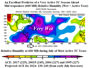
Fig. 1: The 600 MB relative humidity during July for tropical cyclone seasons producing >200 accumulated cyclone energy (ACE) index.
Discussion: The projected accumulated cyclone energy (ACE) index for the 2024 North Atlantic basin tropical cyclone season based on early July seasonal forecasts issued by Colorado State University, Tropical Storm Risk U.K., and Climate Impact Company ranges a robust 230-240. Analog years when ACE index was >200 include 2017, 2005, 2004, and 1995. On average, the analog years began producing hurricanes during the first half of August although 2 major hurricanes were observed in July of 2005. The bulk of tropical cyclones during these very active seasons began generating in late August. An excellent indicator of a busy tropical cyclone season ahead is the 600 MB relative humidity (RH). When the lower mid-troposphere is wet (high RH), the environment for tropical cyclone development is enhanced. During the most active (analog) tropical cyclone years, the July RH was very wet near the Bahamas, the Caribbean Sea, and throughout the central North Atlantic tropics and subtropics (Fig. 1). So far in 2024, the 600 MB RH for July 1-22 is wetter than the analog years and stretches basin-wide across the subtropics and northern tropics (Fig. 2). Once the suppressing influence of Sahara Dust across the North Atlantic subtropics/tropics present during the past 2-3 weeks eases, the North Atlantic tropical cyclone season should roar! Regarding ENSO, the daily southern oscillation index (SOI) has varied wildly during recent weeks indicating the atmosphere is averaging neutral ENSO phase. Upper shear is an issue across the North Atlantic basin now but is likely to ease in AUG/SEP. However, a La Nina climate to enhance tropical cyclone season activity may be slow to develop. The North Atlantic tropics/subtropics SSTA regime remains exceptionally warm!
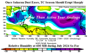
Fig. 2: The relative humidity at 600 MB is wetter in the subtropics/northern tropics during July 2024 so far compared to the most active analog years.