Category-4 Major Hurricane Milton Begins Northeast Turn Toward Florida
10/08/2024, 5:57 am EDTGreat Plains Dry Pattern Continues as Drought Worsens
10/10/2024, 4:45 am EDT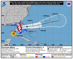
Fig. 1: The NOAA/NHC 5-day forecast track for Category-5 Major Milton.
Discussion: At 5AM EDT, Category-5 Major Hurricane Milton was located at 24.5N/85.4W or about 300 miles southwest of Tampa, FL. Milton is moving northeast at 14 mph with top wind near 160 mph. Central pressure is 907 MB. Milton has maintained category-5 intensity longer than expected. The southwest flow aloft is moving Milton northeastward. However, the hurricane is concentric so weakening effects of shear on the hurricane have not started. Ahead of Milton is a large mass of heavy thunderstorms which will move across Florida today preceding the main event. NOAA/NHC takes Milton to landfall near or just south of Tampa around 1AM tomorrow as a strong category-3 major hurricane. HMON and HWRF hurricane models indicate Milton is a category-4 major hurricane as the eye approaches the coast. The storm surge in the Tampa Bay area and just south remains in the 10-15-foot range. Sustained hurricane force wind extends to 35 miles outside of the eye as the storm moves ashore shrinking to 20 miles as Milton crosses Florida. Milton maintains hurricane intensity across the peninsula. NOAA/NIC increases rainfall amount to 16-20 in. for the Tampa Bay area with 12-16 in. along and just north of the storm track through central Florida. Milton moves off the coast near Melbourne late tomorrow morning and begins to accelerate and become extra-tropical well east of Florida late this week. The storm will maintain strong wind after moving offshore as the Milton becomes extra-tropical. The bulk of the weather is tonight and much of Thursday.
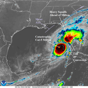
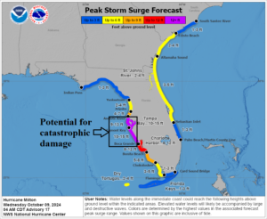
Fig. 2-3: Gulf of Mexico weather satellite view of “Milton” and NOAA/NHC storm surge outlook.
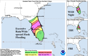
Fig. 4-5: The NOAA/NHC rainfall and flood risk forecast.
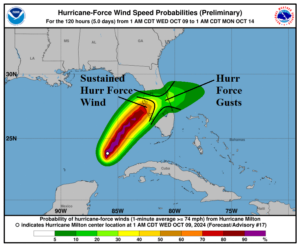
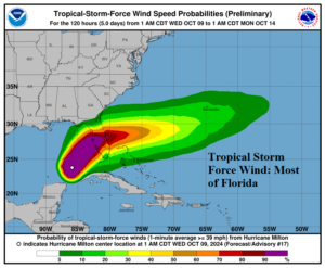
Fig. 6-7: The NOAA/NHC hurricane and tropical storm wind probability profile for Milton.
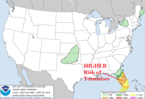
Fig. 8: NOAA/SPC tornado risk area for today and tonight.