Late Season Surge Brings Another Very Active North Atlantic TC Season
12/02/2024, 5:53 am EST
Warmer Changes for December BUT East is Trending Colder Into Early January
12/06/2024, 4:02 pm EST 


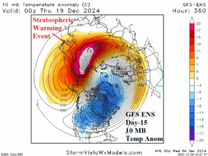
Fig. 1-4: Moderate to strong MJO in the East Indian Ocean to Maritime Continent since the last third of November, cooling Nino34 SSTA, a westerly wind burst with increasing trade winds, and possible stratospheric warming later this month.
Climate alert: Persistent presence of the MJO in the East Indian Ocean to Maritime Continent (Fig. 1) is causing several major climate events to emerge. First, Darwin pressure has lowered and to compensate, Tahiti pressure has increased. Consequently, a lengthy period of positive phase southern oscillation index (+SOI) has developed. +SOI supports increased trade winds which are up-welling cool subsurface waters of the eastern equatorial Pacific. The daily Nino34 SSTA has cooled near the La Nina threshold this week (Fig. 2).
The MJO has also caused a westerly wind-burst (WWB) to form in the East Indian Ocean tropics (Fig. 3) which increases the risk of tropical cyclone activity possibly affecting the northwest coast of Australia in December.
Finally, the persistent MJO and causal WWB has created a scenario where latent heat release to the upper atmosphere and poleward via a Rossby Wave is causing forecast models to indicate a stratospheric warming event across Northeast Asia in the 11-15-day period increasing strength as day 15 arrives (Fig. 4). The stratospheric warming event could trigger an arctic air mass formation across Eurasia late in December if this feature is well organized.

