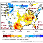
Western Corn Belt Flooding; Eastern Corn Belt Drought Risk. Southern Texas Drought Erased.
06/16/2024, 9:22 am EDT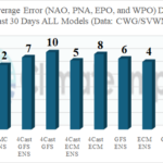
How Is AIFS Doing Vs. Other Forecast Models? Some Preliminary Results
06/26/2024, 2:56 pm EDT
Executive summary: Anticipated during the summer 2024 season is one of the most active tropical cyclone seasons on record with NOAA forecasting as many as 13 hurricanes and 7 major hurricanes. However, the first high impact climate regime of summer 2024 develops before the arrival of the core of hurricane season. There is support, based on evolution of an intense marine heatwave east of New England, to apply the week 1-4 and week 5-6 ahead upper air and sensible weather forecasts from ECMWF to a long-term hot and dry pattern for the Ohio Valley and into the Northeast U.S. Corridor warranting drought development accelerated by persistent heat waves.
Discussion: East of New England and south of the Canadian Maritimes, a large area of much warmer than normal ocean surface has developed (Fig. 1). The intensity of the warm water zone and the aerial coverage of the event warrants marine heat wave (MHW) development. The sudden warming is illustrated in the 30-day SSTA change analysis (Fig. 2). In June, the MHW and upper air pattern are well-correlated as warming of the atmosphere across the warm water zone has caused an amplified high-pressure zone (Fig. 3).
Beginning this week, the ECM “weeklies” model shifts the high-pressure area to the Northeast U.S. causing widespread possible record heat and dryness from the Ohio Valley to the East Coast. Correlation of warm air aloft to the expanding and intensifying MHW east of New England causes ECM to make the high-pressure area over the Northeast U.S. semi-permanent through the next 4 weeks (Fig. 4). Consequently, the Ohio Valley and Northeast U.S. are mostly dry and very warm to hot and humid (Fig. 6) for much of the next 4 weeks (Fig. 5-6). The forecast warrants a drought development zone from the Ohio Valley to the Mid-Atlantic States where soil moisture is already drying during June so far.
The upper-level ridge shifts slightly westward in the ECM week 5-6-ahead forecast (Fig. 7) maintaining dryness in the Ohio to the Tennessee Valley(s) and to a lesser degree the Northeast Corridor (Fig. 8) while widespread anomalous heat persists (Fig. 9). Drought conditions should strengthen given this set-up centered on the eastern Ohio Valley.
The high-pressure area maintains a steady diet of tropical features across the Gulf of Mexico into Texas and Northeast Mexico certain to include tropical cyclone activity.
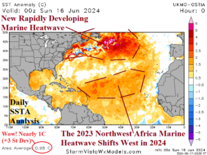
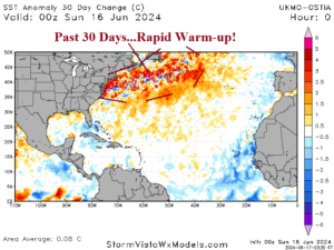
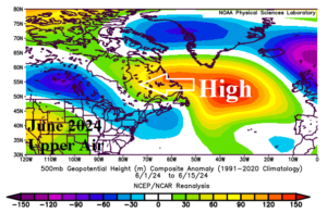
Fig. 1-3: Current daily sea surface temperature anomaly (SSTA) analysis across the North Atlantic basin identifies a rapidly evolving marine heatwave south of the Canadian Maritimes, the 30-day SSTA change, and the upper ridge pattern across the warm SSTA region so far in June.
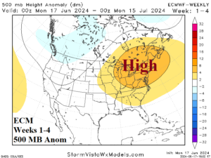
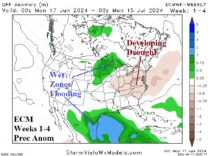
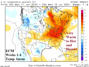
Fig. 4-6: The ECM week 1-4 forecast projects a repositioning of the North Atlantic high-pressure area to the Northeast U.S. causing persistent anomalous dry and hot conditions from the Ohio Valley to the East Coast.
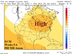
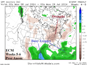
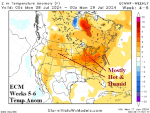
Fig. 7-9: The ECM week 5-6 forecast projects the high-pressure area to persist while shifting slightly westward. Anomalous dry and hot weather continues across the Ohio Valley and into the East U.S.