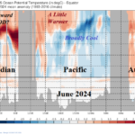
June 2024 Trend Upper 100 Meters Equatorial Global Oceans
07/08/2024, 3:56 pm EDT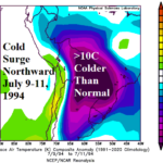
A Review of the July 1994 Cold Outbreak into Brazil
07/17/2024, 3:03 pm EDT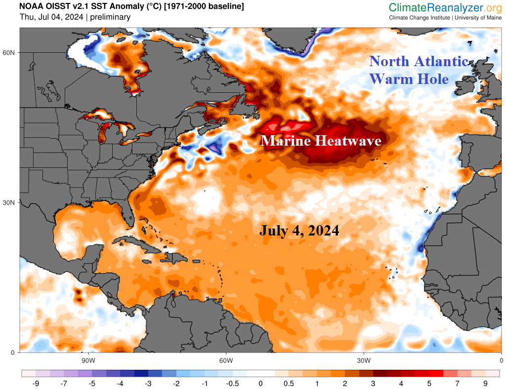
Executive summary: During the past 10+ years, large areas of (mostly) oceanic warming have equaled or surpassed ENSO as leading influences on climate in the middle latitudes. One exception to the warming oceans is the North Atlantic warm hole usually vividly present during the summer season south or southeast of Greenland. So far during meteorological summer 2024, the NAWH pattern is quite strong and located west of Ireland. The influence on the upper air pattern is steady presence of an upper trough over Coastal Northwest Europe with a compensating drought-producing upper ridge over Southeast Europe to Southwest Russia. South of the NAWH regime an intense marine heatwave has formed southeast of Newfoundland with an attendant high pressure aloft across this region compensated for by an upstream trough over Canada. South of the cool Canadian trough a compensating near record hot start to summer in the U.S. is generated. Once again, an example of the profound influence regional SSTA patterns outside of the tropics has on the sensible weather and climate.
What is the North Atlantic warm hole? In 2013, an area of anomalous cool ocean water formed south of Greenland in an otherwise somewhat warmer than normal North Atlantic basin. The area of cool water persisted with notable intensity during the remainder of the decade was attributed to faster melt of the Greenland ice sheet whereas the runoff collected south of Greenland creating a stratified cool layer of ocean water at times blocking northeast progress toward Europe of the Gulf Stream. Aloft, the persistent cool pool of water affected the atmosphere by causing a low-pressure area to form compensated for by an upstream high-pressure ridge over northeast North America and Europe. The upper air pattern associated with the North Atlantic warm hole (NAWH) helps to explain the tendency for warmer than normal climate in eastern North America and Europe, particularly during the wintertime, of much of the past 10+ years.
Discussion: During 2013-18, the NAWH almost always formed south-to-southeast of Greenland with vivid appearance during the summer months. In recent years, the NAWH pattern has changed position from year-to-year suggesting the phenomena may be weakening. In 2019, NAWH was located south of Newfoundland. In 2021 and 2022, the “cool blob” was northwest of Portugal. Last year, the NAWH was the weakest of the past 10 years.
In 2024, the NAWH returns with a vivid presence west of Ireland (Fig. 1). The North Atlantic SSTA pattern features many extremes. Despite the return of the NAWH, the North Atlantic basin SSTA is the warmest on record. A primary contributor to the record warmth is the development of a buoyant marine heatwave southeast of Newfoundland. A marine heatwave off the northwest coast of Africa in 2023 has shifted westward to the North Atlantic subtropics.
The upper air pattern in the mid-to-high latitudes of eastern North America to Europe during meteorological summer so far is well-correlated to the SSTA pattern. The NAWH trough is centered just north of U.K. while the upper ridge associated with the MHW is anchored east of Newfoundland (Fig. 2). To compensate for the NAWH trough, an amplified ridge has caused a Southeast Europe to Southwest Russia drought and attendant hot summer so far (Fig. 3). An elongated trough over Canada is compensation for the MHW ridge in the central North Atlantic. South of the Canadian trough, the U.S. has observed a near record hot start to the summer 2024 season (Fig. 4).
Fig. 1: The daily North Atlantic basin SSTA analysis for July 4, 2024, clearly identifies the NAWH and MHW patterns.
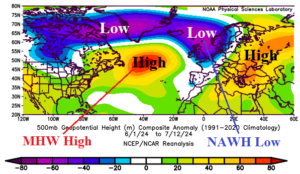
Fig. 2: The North America to Europe upper air pattern for meteorological summer 2024 so far.
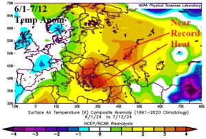
Fig. 3: Europe and Western Russia temperature anomalies for meteorological summer 2024 so far.
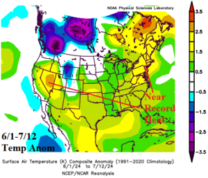
Fig. 4: U.S. temperature anomalies for meteorological summer 2024 so far.