12Z GFS Introduces New TC Threat Next Week in Texas
08/05/2024, 1:41 pm EDTFrost Risk for Southern Brazil Coffee
08/08/2024, 4:36 am EDTChart of the day: The July 2024 rainfall anomaly and soil moisture anomalies across Australia.
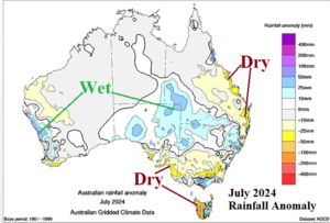
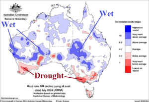
Discussion: During July 2024 localized areas of above normal rain were observed on the West Coast, central continent, and parts of the Southeast Coast. Soil moisture anomalies for July 2024 continue to show drought on the South Coast including southwest continent and Victoria.
Week-2 Ahead Forecast valid August 11-17, 2024: Rains back into Queensland; much of continent is warmer than normal.
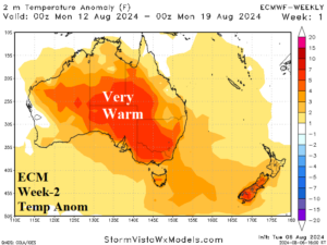
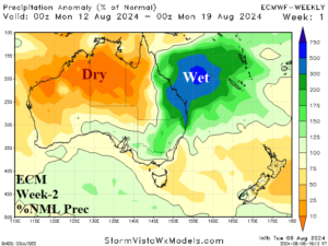
Discussion: A well-amplified high-pressure ridge remains over New Zealand next week with an attendant warmer than normal thermal pattern stretching across most of Australia. An inverted low-pressure trough to the north of the ridge continues to spawn wet weather in eastern Queensland.
Week-3 Ahead Forecast valid August 18-24, 2024: Turning showery on the South Coast.
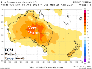
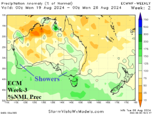
Discussion: Persistent strong negative phase of the southern annular mode causes a deep trough to emerge just south of Australia. Showery weather along the northern periphery of the trough stretches along the Australia South Coast. North of the trough, much of Australia remains warmer than normal.
Week-4 Ahead Forecast valid August 25-31, 2024: Mostly dry and warm except showery southwest coast.
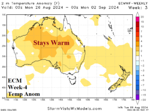
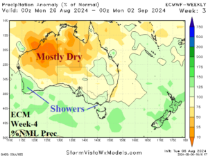
Discussion: Upper trough shifts east to replace the dominant ridge over New Zealand. New Zealand rains develop due to the trough. In Australia, mostly warmer and drier than normal prevails except showery across the southwest coast.