
April 2025 Climate Impact Company Marine Heat Waves Outlook
04/16/2025, 4:41 pm EDT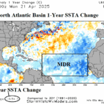
North Atlantic SSTA Much Cooler Than 1 Year Ago
04/22/2025, 6:01 am EDT
Highlight: Spot check using operational and AI models U.S. medium range forecasts.
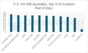
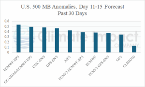
Fig. 1-2: All operational models 6-10-day and 11-15-day forecast verification of 500 MB anomalies for the past 30 days.
Discussion: During the past 30 days, not surprisingly, the ECM ENS has reigned number 1 forecasting North America 500 MB heights during the 6-10-day and 11-15-day periods (Fig. 1-2). The AI Graph Cast finished number 2. Each model displaying top skill forecasting the North America weather pattern during the medium range was established during the winter 2024-25 season and continues well into spring. Another leading AI model, AIFS, has improved skill shifting out of the middle rankings to as high as number 3 in the 6-10-day period. The leading operational models, ECMWF and GFS, are lagging with GFS finishing last (except for 10-year climatology) in each period.
The 2-meter medium range temperature anomaly forecast skill across North America during the past 30 days reveals ECM ENS as the top model for both periods (Fig. 3-4). The AI Graph Cast finished number 2 for the 6-10-day period while the improving CMC ENS reached number 2 in the 11-15-day period. Once again, GFS produced the lowest skill.
The AI Graph Cast medium range temperature forecast bias during the past 30 days for North America indicates a warm bias across the West and Southern Canada in the 6-10-day period (Fig. 5) with stronger bias in the 11-15-day period (Fig. 6).
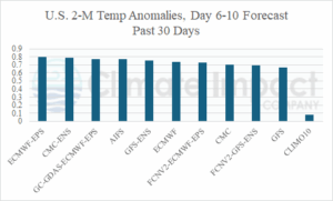
Fig. 3-4: AI Graph Cast medium range temperature anomaly forecast error/bias for the past 30 days.
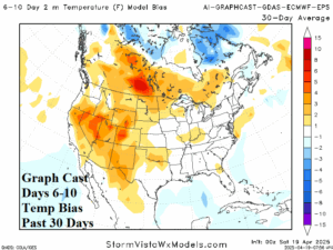
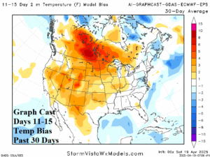
Fig. 5-6: AI Graph Cast medium range temperature anomaly forecast error/bias for the past 30 days.