AI/Operational Models Spot Check Verification
04/19/2025, 2:47 pm EDT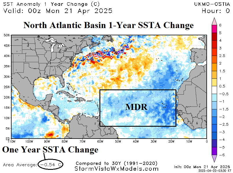
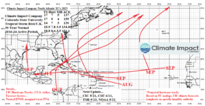
Fig. 1: The Climate Impact Company 2025 North Atlantic hurricane tracks outlook and CIC/CSU/TSR seasonal activity forecast.
Discussion: The 2025 North Atlantic basin seasonal tropical cyclone activity forecasts are issued with the NOAA/NHC outlook scheduled for one month from now. The seasonal forecasts issued by Climate Impact Company, Colorado State University, and Tropical Storm Risk/U.K. produce a range of 14-17 tropical storms, 7-9 hurricanes, and 3-5 major hurricanes with an ACE index of 120-155. Expected is closer agreement with updated forecasts issued later in May and early June. The Climate Impact Company hurricane tracks forecast indicates 2 strikes to the U.S. Coast (Fig. 1). This forecast is somewhat dependent on the SSTA pattern for summertime. The hurricane tracks forecast will be updated May 21.
The current SSTA pattern across the North Atlantic basin is somewhat cooler than one year ago (Fig. 2-3). The current North Atlantic basin SSTA is +0.25C which is close to +1 St Dev compared to +0.79C one year ago which is >+3 St Dev. The main development region (MDR) is the center of the cooler SSTA change and right now, is almost exactly at normal for late April. The Caribbean Sea marine heatwave has weakened. The Gulf of Mexico is warmer than normal but quite variable through early 2025. A frigid counter current has developed just north of the Gulf Stream off the Northeast U.S. Coast. The central North Atlantic basin is warmer than normal while the northeast/east North Atlantic marine heatwave is weakening. Cooler SSTA during early-to-middle spring are not unusual but the April 2025 cooling is much stronger than recent years. All global SSTA forecast models are projecting a warm-up for the tropical cyclone season, especially north of the deep tropics. The global SSTA models are strongly biased by recent history and are not as cool with their initialization across North Atlantic basin as observed in April. The North Atlantic SSTA trend over the next 30 days will be a leading catalyst to any changes in the seasonal forecasts scheduled for new release in one month.
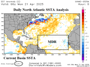
Fig. 2: Current North Atlantic basin SSTA analysis.
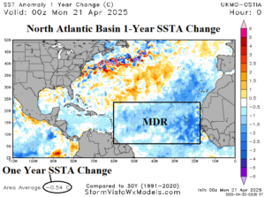
Fig. 3: The North Atlantic basin 1-year SSTA change.