
Tracking Winter Weather Events in the East
02/05/2025, 12:57 pm EST
Australia Climate Forecast is Wet East Coast Much of 2025
02/09/2025, 7:40 pm EST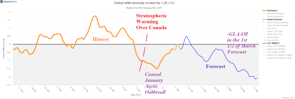
Highlight: Is there sudden stratospheric warming ahead in early March? Models don’t “know”. But! Steep -GLAAM forecasts suggest trouble brewing.
Fig. 1: The global atmospheric angular momentum anomaly forecast into mid-March. BLUE is forecast; ORANGE is 90-day history.
Discussion: Utilizing CFS V2 extended range forecasts of the stratosphere there is not an obvious sign of an emerging sudden stratospheric warming (SSW) event during late FEB/early MAR. The ECM forecast is not available. HOWEVER, a major slowdown of the global atmospheric angular momentum (GLAAM) is in the forecast through mid-March (Fig. 1). When -GLAAM occurs, the mid-latitude upper-level pattern has the tendency to produce amplified low-pressure troughs. A recent example is the polar vortex episode and attendant Winter Storm Enzo in the U.S. during January. Stratospheric warming occurred over Canada leading to that episode. However, the stratospheric warming was not a classic event as the Eurasia side of the North Pole was colder than normal. The -GLAAM index forecast for the first half of March is sharply more negative than the Canadian-biased event of January. Whether SSW events trigger the -GLAAM (or not) is unclear. However, the -GLAAM forecast of the magnitude indicated suggests winter trouble ahead for March.