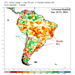
The Ongoing Drought Risk in Brazil and Argentina
02/02/2025, 11:43 am EST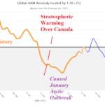
Is There Sudden Stratospheric Warming Ahead in Early March?
02/06/2025, 1:53 pm EST
Headline: Tracking winter weather events in the East.
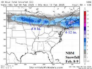
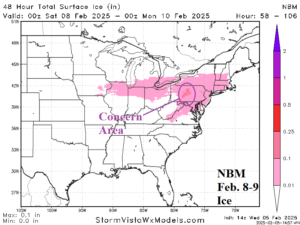
Fig. 1-2: NBM forecast of potential snowfall and ice accretion for Feb. 8-9.
Discussion: A large area of snow is forecast to the north of a slowly developing low pressure system, most intense off the Northeast Coast, this weekend. The NBM model forecasts 4-8 in. of snow in the Midwest which looks a bit high, and a more aggressive snowfall forecast, for New England, especially near the coast as the storm strengthens offshore early Sunday (Fig. 1). There is a freezing rain/ice accretion risk across a large area most likely causing impacts over west-central Pennsylvania (Fig. 2).
Next week, a second storm brings a large snowfall area and possible icing to the Northeast Corridor with impacts as far south as Virginia (Fig. 3-4). The snowfall amount forecast is a little less than yesterday while the icing risk is broader. Next week’s storm (in the East) is focused on Wednesday.
As a reminder, a developing winter weather event stretches from the Midwest to the Appalachians today and across the Northeast Corridor tonight (Fig. 5). The primary issue is the risk of moderate icing in northeast West Virginia to Southwest Pennsylvania.
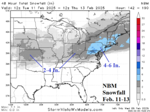
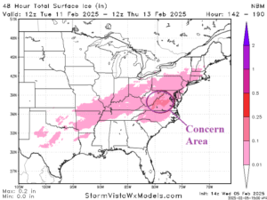
Fig. 3-4: NBM forecast of potential snowfall and ice accretion for Feb. 11-13.
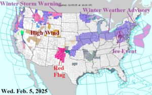
Fig. 5: NOAA/NWS weather watch, warning, and advisory areas.