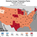
Warmest U.S. Meteorological Autumn on Record
12/09/2024, 4:45 pm EST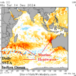
Marine Heatwave Influence Dominate Australia Month 1-4 Ahead Climate Outlook
12/15/2024, 7:54 pm ESTHighlight: Another busy season in 2025!
Executive summary: The 2016-24 active period for tropical cyclone activity in the North Atlantic basin is forecast to continue in 2025. During the 2025 North Atlantic tropical cyclone season similar climate conditions are forecast including neutral ENSO shifting back to La Nina and a warmer than normal North Atlantic basin. The preliminary seasonal tropical cyclone activity forecast for the 2025 season indicates 20 tropical storms, 11 hurricanes, and 6 intense hurricanes plus the 6th highest ACE index (193) on record. The risk of a dangerous season in the Gulf of Mexico is >50 percent while analogs indicate mixed risk for the U.S. East Coast.
Discussion: The 2024 North Atlantic tropical cyclone season climate was characterized by strong upper ocean heat especially in the Caribbean Sea and Gulf of Mexico, continuation of much warmer than normal sea surface temperature anomalies, and a low upper-level shear environment associated with a developing La Nina climate. Activity was held back during mid-to-late meteorological summer due to stronger than normal trade winds with an axis across the African Desert to the northern Caribbean Islands.
During the 2025 North Atlantic tropical cyclone season, a similar ENSO regime is expected: Neutral ENSO possibly shifting back to La Nina (Fig. 1). The Atlantic multi-decadal oscillation is likely to remain very warm (Fig. 2). Due to these factors, the 2025 season should produce as much as the 2016-24 active period totals (19 tropical storms, 9 hurricanes, and 4 intense hurricanes).
During the 9-year active period (propelled by a much warmer than North Atlantic Ocean surface), the Gulf of Mexico was dangerously active 5 of the 9 years. Consequently, the risk of another dangerous hurricane season in the Gulf of Mexico is >50%.
The NOAA/CPC probabilistic rainfall forecast for AUG/SEP/OCT 2025 indicates above normal risk of heavy rain in the Mid-Atlantic States suggesting significant coastal tropical cyclone risk in that region (Fig. 3).
The analog years presenting neutral ENSO to weak La Nina transition coupled with a warm to very warm North Atlantic basin include 2024, 2017, 2016, and 2005. An equally weighted consensus of the tropical cyclone activity for each analog year implies 20 tropical storms, 11 hurricanes, 6 intense hurricanes, and 193 ACE index (Table 1). The activity level is higher than the current 9-year active period, 30-year normal, and 1950-2024 normal (Table 2). The ACE index forecast is 6th highest in the 1950-2024 record. The top 5 years (1950, 1995, 2004, 2005, and 2017) were each very active in the Gulf of Mexico with mixed results on the East Coast.
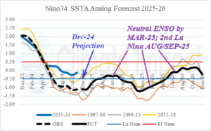
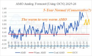
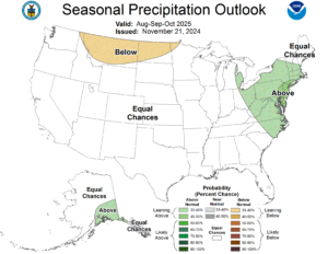
Fig. 1-3: The Climate Impact Company constructed analog forecast of Nino34 SSTA and AMO index plus the NOAA/CPC probabilistic rainfall forecast for AUG/SEP/OCT 2025.
| Tropical Storms | Hurricanes | Hurricane Index | ACE Index | |
| 2024 | 19 | 11 | 5 | 162 |
| 2017 | 17 | 10 | 6 | 225 |
| 2016 | 15 | 7 | 4 | 141 |
| 2005 | 28 | 15 | 7 | 245 |
| Forecast Consensus | 20 | 11 | 6 | 193 |
Table 1: The analog years used to generate the preliminary 2025 North Atlantic basin tropical cyclone season forecast.
| Tropical Storms | Hurricanes | Hurricane Index | ACE Index | |
| 2025 Forecast | 20 | 11 | 6 | 193 |
| Last Year | 19 | 11 | 5 | 162 |
| 9-Year | 18.8 | 8.6 | 3.9 | 151.1 |
| 30-Year | 15.9 | 7.8 | 3.5 | 134.8 |
| 1950-2024 | 12.5 | 6.5 | 2.6 | 106.3 |
Table 2: The preliminary 2025 forecast compared to various climatology.

