New NOAA Long-lead Forecasts for Winter 2024-25
11/21/2024, 12:40 pm EST
First New England Snowfall Event of the Season
11/26/2024, 8:37 am EST
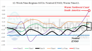
Fig. 1: The 12-week Nino SSTA observations indicate ENSO is in neutral phase.
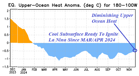
Discussion: The ENSO diagnostics remain tricky. Although NOAA/CPC reports a significant warming of the Nino12 SSTA region last week reaching above the El Nino threshold (Fig. 1), the past 2-3 days show that the warm anomaly is beginning to reverse. Trade winds have increased across the equatorial eastern Pacific during the past 1-2 weeks due to emergence of a steady positive phase southern oscillation index (SOI). The +SOI pattern is due to the convection phase of the Madden Julian oscillation (MJO) across Maritime Continent with compensating higher surface pressure in the tropical East Pacific. Despite the recent warming trend of the Nino SSTA regions maintain neutral ENSO, the steady +SOI regime suggests trade winds will begin to up-well cool water and cool the surface. Whether the cooling is sufficient to cause a La Nina onset is questionable as upper ocean heat in the eastern equatorial Pacific is cool but losing intensity (Fig. 2).

Fig. 2: The upper ocean heat anomalies east of the Dateline indicate cooler than normal waters able to ignite La Nina onset are fading.

