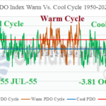
October 2024 Produces the Strongest Monthly -PDO in the 1950-2024 Climatology
11/08/2024, 3:50 pm EST
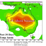
The Super-hot Australia Pattern Eases
11/12/2024, 6:29 am EST| Tropical Storms | Hurricanes | Intense Hurricanes | ACE Index | |
| 2024 So Far | 17 | 11 | 5 | 159.8 |
| Normal So Far | 13.8 | 6.9 | 3.1 | 118.6 |
| NOAA Forecast | 17-25 | 8-13 | 4-7 | 200-240 |
Table 1: The North Atlantic basin tropical cyclone activity so far compared to normal and the NOAA seasonal forecast.

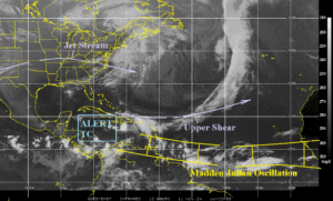
Fig. 1: The North Atlantic basin weather satellite view.
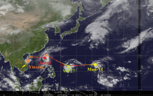
Discussion: After Rafael, North Atlantic basin tropical cyclone activity is firmly in the above normal category and within the range of buoyant seasonal activity forecast by NOAA/NHC (Table 1). Rafael dissipated over the weekend in the central Gulf of Mexico due to dry air entrainment. An ALERT is posted for the Caribbean Sea for tropical cyclone development by this upcoming weekend (Fig. 1). In the Northwest Pacific, seasonal activity is slightly below normal so far (Table 2). However, the satellite view reveals 4 separate systems in-place now and each is drifting westward (Fig. 2).
| Tropical Storms | Hurricanes | Intense Hurricanes | ACE Index | |
| 2024 So Far | 23 | 13 | 7 | 171.9 |
| Normal So Far | 23.1 | 14.5 | 8.5 | 271.4 |
| TSR Forecast | 24 | 14 | 6 | 177 |
Table 2: The North Atlantic basin tropical cyclone activity so far compared to normal and the NOAA seasonal forecast.

Fig. 2: The West Pacific basin weather satellite view.

