The Valencia, Spain Floods
11/01/2024, 8:25 am EDT
Rafael Runs into Strong Upper Shear Before Reaching Gulf Coast
11/05/2024, 6:05 am EST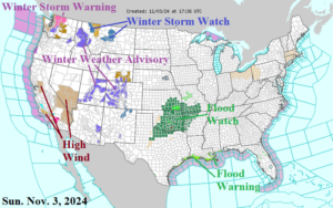
Fig. 1: The NOAA/NWS weather watch, warning, and advisory areas.
Discussion: Wind, snow, and heavy rain areas highlight the afternoon high impact weather map (Fig. 1). In the West, high wind is an issue in parts of California and Nevada. Significant snow is likely across the Northern Cascades where a Winter Storm Warning is in effect. Widespread Snow Advisories are in effect for Idaho to the Central Rockies. A major rainfall event unfolds in the Mid-south U.S. where flood warnings are already in effect for parts of Oklahoma and Kansas. The latest NOAA/WPC 7-day quantitative precipitation forecast (QPF) indicates up to 5-10 additional inches of rain centered on Oklahoma to Arkansas this week (Fig. 2). The heavy rain pattern will extend from Texas to the Great Lakes region, easing drought conditions and raising low river levels. Severe thunderstorms including tornado risk affects the southern Great Plains today and Monday and possibly the northwest Gulf States on Tuesday.
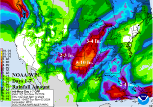
Fig. 2: NOAA/WPC 7-day quantitative precipitation forecast for the U.S.
Tropical Disturbance 97L located in the south-central Caribbean Sea is forecast to become a tropical storm traveling northwestward across Western Cuba Wednesday with a low confidence 4-5-day forecast track into the northeast Gulf of Mexico (Fig. 3). Tropical cyclone model intensity forecasts indicate tropical storm intensity and for the moment doubt hurricane risk (Fig. 4). A northwestward traveling tropical cyclone into the Gulf of Mexico is rare.
The 12Z GFS U.S. medium range temperature anomaly forecast looks familiar. Relentless anomalous warmth across the Central and East U.S. (Fig. 5-6). Consequently, the already very warm U.S. gas population weight HDD forecast trend is warmer (Fig. 7).

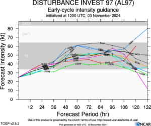
Fig. 3-4: Tropical cyclone model tracks and intensity forecasts for Tropical Disturbance 97L.
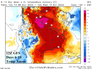
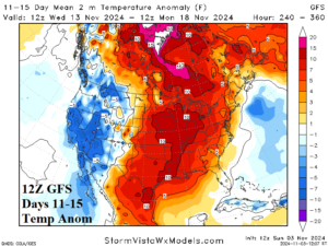
Fig. 5-6: The 12Z GFS medium range temperature anomaly forecast.
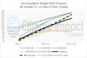
Fig. 7: The U.S. gas population weight HDD forecast utilizing all models, their consensus and comparison with 24 hours ago and the 30-year/10-year normal.

