Much Needed Rainfall Appears in Great Plains Forecast
10/14/2024, 5:37 am EDTHeavy Rains Southern Brazil While Northern Brazil Becomes Hot/Dry
10/16/2024, 9:40 am EDTChart of the day: MJO and Snow
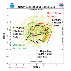
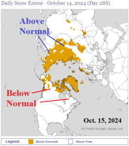
Discussion: Transient Madden Julian oscillation (MJO) alters the prevailing jet stream pattern in the mid-latitudes that cause our sensible weather. In October, MJO departing the tropical Indian Ocean (occurring now) correlates to cool outbreaks in the East U.S. as encountered this week. The MJO shifts to phase_5/Phase_6 (across the Pacific) over the next 2 weeks causing another national warm-up. In the 16-30-day period, the MJO shifts across the tropical Atlantic and Africa region which can cause a colder pattern to emerge. The warm ECM “weeklies” (below) may be too warm in the week-4 period. Snow cover is ahead of schedule in Asia, typical of the past decade caused by cold wind across the open water north of the continent.
Week-2 Ahead Forecast valid October 20-26, 2024: Warmth is expansive.
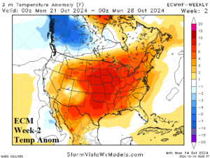
Discussion: Next week brings return of the warm pattern in the Great Plains expanding into the East after the short-term chill of this week. Cooler in the West and potentially stormy on the coast.
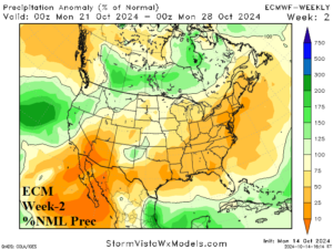
Week-3 Ahead Forecast valid October 27-November 2, 2024: Still warm, wet on West Coast, Midwest showers.
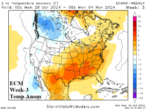
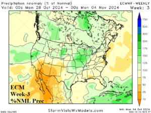
Discussion: Chance of much needed rain across the Midwest States. South and east of the wet weather zone, the pattern is very warm. Cold weather aligns Western Canada.
Week-4 Ahead Forecast valid November 3-9, 2024: Is the forecast too warm?
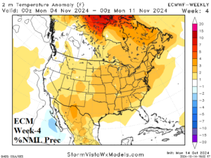
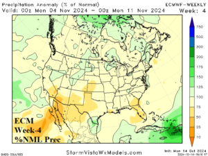
Discussion: ECM “weeklies” are very warm in early November. As cited above, due to MJO, cooler surprises are possible.