NAWH Pattern Dominates Europe Summer Climate
10/01/2024, 8:11 am EDT
Moderate Madden Julian Oscillation Triggers Increased Global Atmospheric Angular Momentum
10/13/2024, 10:42 am EDT| 2024 Season | Tropical Storms | Hurricanes | Intense Hurricanes | ACE Index |
| So far | 13 | 9 | 4 | 137.6 |
| Normal | 11.9 | 5.7 | 2.6 | 103.6 |
Table 1: The North Atlantic basin tropical cyclone activity for 2024 so far compared to normal (for Oct. 10).

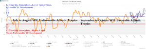
Fig. 1: The 15-day SOI forecast (blue) and past 120 days of daily SOI.
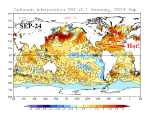
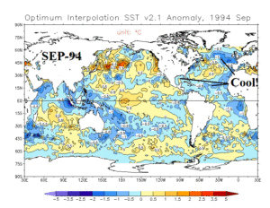
Discussion: The 2024 tropical cyclone season has certainly seen a destructive uptick in recent weeks. Seasonal totals are now above normal, most notably with the number of hurricanes and the rapidly increasing accumulated cyclone energy (ACE) index (Table 1). The North Atlantic basin including the Gulf of Mexico remains considerably warmer than normal supporting an active season as predicted by most forecasters earlier this summer. However, the westerly shear aloft was enough to suppress activity during July and August. During that time, the daily southern oscillation index (SOI) was mostly negative and representative of an El Nino climate which is supportive of increased westerly shear across the North Atlantic tropics (Fig. 1). However, the SOI flipped to positive phase during late summer and has stayed away from the negative phase since that time causing westerly shear to ease and allow conditions for tropical cyclones to develop. The super warm Gulf of Mexico and Caribbean Sea have contributed to the intensity of recent epic storms. Note the anomalous warmth of global oceans in September 2024 analysis from NOAA compared to 30 years ago (Fig. 2-3). The warmer oceans are causing stronger intensity storms.


Fig. 2-3: Comparing global sea surface temperature anomalies for September of 2024 vs. September of 1994.
