PTC Nine Becomes Named Storm Tonight; HWRF Indicates NE Gulf Category-4 Major Hurricane
09/24/2024, 6:05 am EDTHurricane Model Peak Intensity Forecasts into Category-4 Major Hurricane Level for Helene
09/26/2024, 8:35 am EDTDiscussion: The recent tendency of rainfall in Brazil has been some benefit from wet weather across the southern sugarcane and coffee growing areas (Fig. 1). Eastern Argentina has also shifted wetter. However, in the 1-5-day forecast, much of Brazil reverts to the dry and hot pattern common during recent weeks. The rains shift to the Uruguay/Brazil border while Western Brazil is wetter (Fig. 2). In the medium range, the Southeast Brazil rains shift slightly northward during the 6-10-day period (Fig. 3). In the 11-15-day forecast, the wet weather edging from western to central Brazil extends to the wet zone in Southeast Brazil causing a larger aerial coverage of rainfall (Fig. 4).
In the Midwest U.S., wet weather associated with Helene is on the way. However, according to AIFS, the heavy rains stay along the Ohio River and southward while rains into the U.S. Corn Belt are less than indicated earlier this week (Fig. 5). In fact, Iowa to northwest Illinois, may miss all the rain. In the 6-10-day period, the wet weather is shifting eastward although lingering across the eastern part of the Ohio Valley (Fig. 6). The AIFS forecast for the 11-15-day period is wet weather associated with a cold front across the Upper Midwest (Fig. 7).
The Nino34 SSTA has cooled to the La Nina threshold (Fig. 8). The 30-day change is an impressive -0.52C. The southern oscillation index was neutral much of the past 1-2 weeks correlated to easing trade winds. However, +SOI is forecast to re-emerge (Fig. 9). The subsurface waters in the equatorial East Pacific have cooled significantly the past 30 days (Fig. 10-11) indicating increased energy to fuel La Nina if trade winds become established.
After Helene, both GFS and ECM indicate potential for another dangerous storm to affect the Gulf of Mexico region (Fig. 12-13).
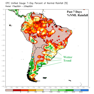
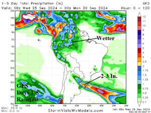
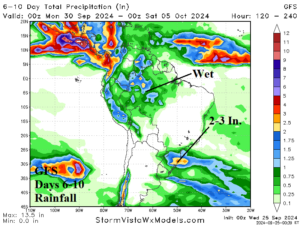
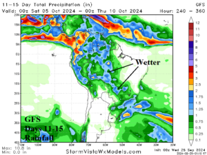
Fig. 1-4: The percent of normal rainfall across South America for Sep. 17-23, 2024 and the GFS 15-day rainfall forecast.
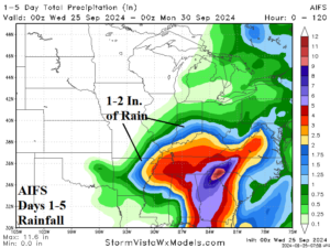
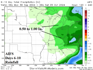
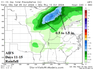
Fig. 5-7: AIFS 15-day rainfall amount forecast across the U.S. AG Belt.
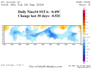
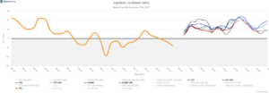
Fig. 8-9: The daily Nino34 SSTA and 15-day southern oscillation index forecast.
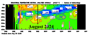
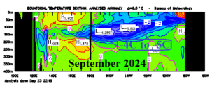
Fig. 10-11: The subsurface upper ocean heat is cooling east of the Dateline in the equatorial Pacific Ocean.
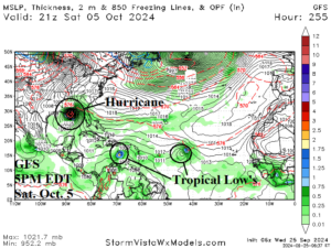
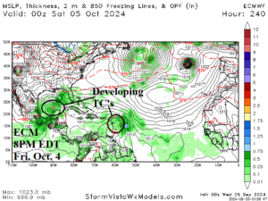
Fig. 12-13: The GFS and ECM indicates additional possible important storms affecting the Gulf of Mexico after Helene.