NOAA Long-lead Climate Forecasts; CIC Comparisons and SEP/OCT/NOV High Impact Climate
08/15/2024, 10:32 am EDTAugust 2024 Marine Heatwave Report
08/20/2024, 8:42 am EDT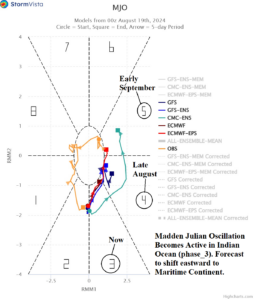
Fig. 1: The MJO 15-day forecast utilizing all models indicates presence in the Indian Ocean (phase_3) forecast to move eastward to Maritime Continent.
Discussion: After a month-long dormant period, the Madden Julian oscillation (MJO) has reactivated over the tropical Indian Ocean (Fig. 1). The 15-day forecast utilizing all operational models indicates MJO will move east to Maritime Continent over the next 15 days. The MJO enhances convection, certainly evident in the tropical Indian Ocean and surrounding areas (Africa, India, and Western Indonesia) now where heavy rain is occurring (Fig. 2). To compensate, the downstream subsidence phase of the Madden Julian oscillation suppresses tropical convection (Fig. 3) which may explain why after Ernesto, no tropical cyclone activity is expected during the remainder of August in the tropical North Atlantic.
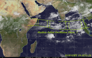
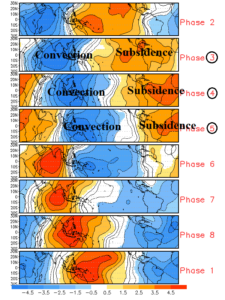
Fig. 2-3: Current IR weather satellite view of the Indian Ocean and the response of anomalous convection to the MJO phase in the tropical latitudes.
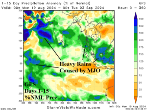
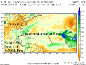
Fig. 4-5: The 15-day percent of normal rainfall forecast (by GFS) indicates widespread heavy rains in the Indian Ocean and surrounding areas while ECM ENS projects patchy wet areas in the North Atlantic tropics and very dry weather in the U.S.