Heavy Rain Episode Departing Australia East Coast
08/14/2024, 4:45 am EDTNOAA Long-lead Climate Forecasts; CIC Comparisons and SEP/OCT/NOV High Impact Climate
08/15/2024, 10:32 am EDTCharts of the day: NOAA/NHC North Atlantic SSTA analysis.
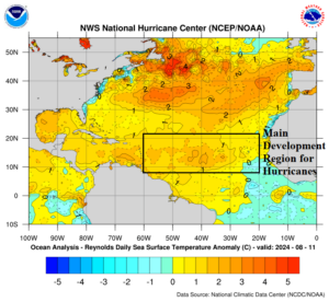
Discussion: The NOAA/NHC sea surface temperature anomaly (SSTA) analysis for Aug. 11, 2024, indicates above to well above normal ocean temperatures for most of the North Atlantic basin including the west and central Main Development region for hurricanes and Gulf of Mexico.
Week-2 Valid August 25-September 1, 2024: Expect significant storms!
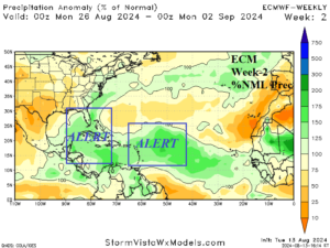
Discussion: Two ALERTS are posted for the Western Caribbean Sea to Florida and the central North Atlantic tropics. At least 2 hurricanes are expected during late August. Florida and the Southeast U.S. Coastline are at risk of tropical cyclone implications.
Week 3 Valid September 2-8, 2024: More hurricanes!
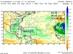
Discussion: Note the soaking wet regime across West Africa indicating strong tropical waves are emitted into the tropical North Atlantic. ALERTS are posted in the central/eastern Caribbean Sea and central/western Gulf of Mexico. Expected are at least 2 hurricanes.
Week 4 Valid September 9-15, 2024: Gulf of Mexico ALERT.
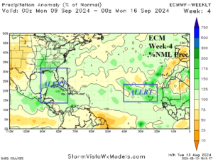
Discussion: An ALERT is posted for the eastern Gulf of Mexico and northwest Caribbean Sea. 1 or 2 hurricanes may form in this region as mid-September approaches. An ALERT is posted for the outer tropics.