Big Rainstorm Ahead for Florida and the East Coast!
08/02/2024, 8:55 am EDT12Z GFS Introduces New TC Threat Next Week in Texas
08/05/2024, 1:41 pm EDT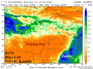
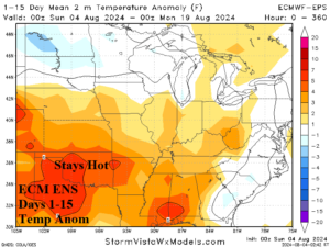
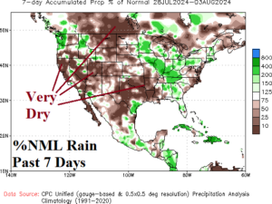
Fig. 1-3: The ECM 10-day percent of normal rainfall forecast across the U.S. AG Belt plus the 15-day temperature anomaly forecast by ECM ENS. Added is the 7-day percent of normal rainfall across the U.S. for the past 7 days.
Discussion: The rainfall outlook across the eastern half of the U.S. through the next 10 days features two extremes. Historic rainfall associated with inland-traveling Debby in the East while on the back side of the heavy rain, an arid pattern continues across the Mid-south States (Fig. 1). In the dry zone, mostly steady hot weather continues over the next 15 days (Fig. 2). During the past 7 days, the Mid-south U.S. has received very little or no rainfall (Fig. 3).
The Canadian prairies turn wet this week as a cold front slowly moves across the region. ECM ENS maintains a showery pattern in the medium range while other models are drier. The 15-day ECM ENS percent of normal rainfall forecast certainly indicates much needed rains for this drought-parched zone (Fig. 4).
Elsewhere, a sharp upper trough delivers a cool burst to South America during the 6-10-day period (Fig. 5). The risk of <32F is evident across Argentina with a slight risk as far north as Southeast Brazil (Fig. 6).
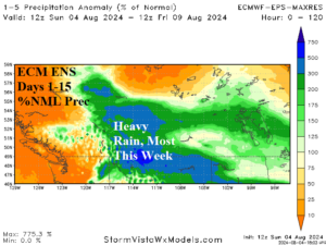
Fig. 4: The 15-day ECM ENS percent of normal rainfall outlook for the Canadian Prairies.
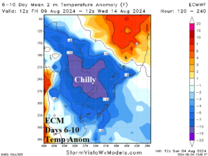
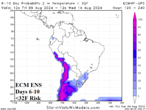
Fig. 5-6: The ECM 6-10-day temperature anomaly outlook for Brazil and South America risk of <32F during this time.