East U.S. Cold Days 11-15: GFS/ECM Vs. AI Forecasts
11/26/2024, 8:40 am EST
Strong MJO Causal to Stratospheric Warming Event Later December?
12/04/2024, 8:57 am ESTHighlight: The second-most costly tropical cyclone season on record featured two unique catastrophic tropical cyclones (Helene and Milton).
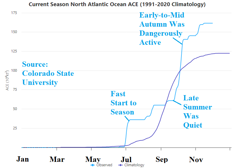
Discussion: The 2024 North Atlantic basin tropical cyclone season ended on November 30. This year, the final tally on tropical cyclone activity was 18 tropical storms, 11 hurricanes, and 5 major hurricanes with an accumulated cyclone energy (ACE) index of 161.6. The above normal activity maintains the recent pattern (2016-24) of very active (and dangerous) tropical cyclone seasons. The seasonal activity was most notable for Category-4 Major Hurricane Helene’s inland path toward the Southern Appalachian Mountains in which the interaction between a weakening tropical cyclone and mountainous terrain caused a massive destructive and lethal flood. The strongest storm of the season was the first major hurricane to travel eastward from its origin over the southwest Gulf of Mexico to the Florida Panhandle. Milton reached category-5 major hurricane intensity with a central pressure of 897 MB north of the Yucatan Peninsula. Helene (>$120B) and Milton (>$85B) propelled a seasonal hurricane damage cost to >$222B, the second-most costly (behind 2017) on record. The active North Atlantic basin season was propelled by above to much above normal upper ocean heat of the North Atlantic basin particularly in the Caribbean Sea and Gulf of Mexico. Although La Nina did not officially develop, a weak La Nina climate (based on multivariate ENSO index) was present and contributing to the active season. Mid-season activity was held back by a lengthy period of Saharan Dust stabilizing the subtropics and tropics. Once the Sharan Dust abated, seasonal activity surged. Tropical cyclone seasonal forecasts from Colorado State University, Tropical Storm Risk/U.K., and Climate Impact Company featured the highest totals ever issued (since 1984). The seasonal forecasts were considered an over-forecast until a surge of late season activity brought seasonal observed activity closer to the forecast. The NOAA seasonal forecast range proved most accurate. Take away’s from the 2024 season are as long as the Gulf of Mexico (and Caribbean Sea) stay warmer than normal, and El Nino is not present, damaging tropical cyclones including major hurricanes are at greater risk than normal to the U.S. especially in the Gulf of Mexico. The trend of West Coast of Florida tropical cyclone impacts continues to increase. The warmer Gulf of Mexico waters support stronger tropical cyclones with farther inland impacts such as Helene’s interaction with the southern Appalachians which caused a historic flood. Seasonal forecasts need to increase accountability for the presence of Saharan Dust.
| Tropical Storms | Hurricanes | Intense Hurricanes | ACE Index | |
| 2024 | 19 | 11 | 5 | 161.8 |
| Normal | 14.2 | 7.2 | 3.2 | 121.8 |
| 2016-24 | 18,8 | 8.6 | 3.9 | 151.1 |
Table 1: The 2024 North Atlantic basin seasonal totals compared to 30-year normal and the 2016-24 active period.
| Year | Storm# | Name | Dates TC Active | Max Wind (kts) | MSLP (mb) | Named Storm Days | Hurricane Days | Major Hurricane Days | Accumulated Cyclone Energy |
| 2024 | 1 | ALBERTO | 6/19-6/20 | 45 | 993 | 1.25 | 0.00 | 0.00 | 0.8 |
| 2024 | 2 | BERYL | 6/29-7/8 | 145 | 934 | 10.00 | 6.25 | 4.50 | 35.1 |
| 2024 | 3 | CHRIS | 7/1-7/1 | 35 | 1005 | 0.50 | 0.00 | 0.00 | 0.2 |
| 2024 | 4 | DEBBY | 8/4-8/8 | 70 | 979 | 5.00 | 0.50 | 0.00 | 4.6 |
| 2024 | 5 | ERNESTO | 8/12-8/20 | 85 | 967 | 7.75 | 5.25 | 0.00 | 14.4 |
| 2024 | 6 | FRANCINE | 9/9-9/12 | 85 | 972 | 3.00 | 1.25 | 0.00 | 4.7 |
| 2024 | 7 | GORDON | 9/13-9/15 | 40 | 1004 | 2.25 | 0.00 | 0.00 | 1.3 |
| 2024 | 8 | HELENE | 9/24-9/27 | 120 | 938 | 3.25 | 2.00 | 0.50 | 7.1 |
| 2024 | 9 | ISAAC | 9/26-9/30 | 90 | 968 | 4.50 | 2.25 | 0.00 | 7.8 |
| 2024 | 10 | JOYCE | 9/27-9/29 | 45 | 1001 | 2.50 | 0.00 | 0.00 | 1.7 |
| 2024 | 11 | KIRK | 9/30-10/7 | 125 | 934 | 7.25 | 5.75 | 3.25 | 23.4 |
| 2024 | 12 | LESLIE | 10/3-10/12 | 90 | 972 | 9.50 | 5.50 | 0.00 | 16.1 |
| 2024 | 13 | MILTON | 10/5-10/10 | 155 | 897 | 5.00 | 4.00 | 2.75 | 23.5 |
| 2024 | 14 | NADINE | 10/19-10/19 | 45 | 1003 | 0.75 | 0.00 | 0.00 | 0.5 |
| 2024 | 15 | OSCAR | 10/19-10/22 | 75 | 986 | 3.25 | 1.50 | 0.00 | 4.1 |
| 2024 | 16 | PATTY | 11/2-11/4 | 55 | 982 | 2.50 | 0.00 | 0.00 | 2.0 |
| 2024 | 17 | RAFAEL | 11/4-11/10 | 105 | 956 | 6.00 | 3.25 | 0.50 | 12.5 |
| 2024 | 18 | SARA | 11/14-11/17 | 45 | 997 | 3.00 | 0.00 | 0.00 | 1.9 |
Table 2: Colorado State University summary of the North Atlantic basin 2024 named storms.
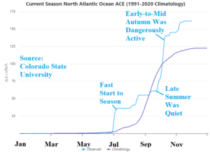
Fig. 1: Colorado State University cumulative accumulated cyclone energy index identifying the late season activeness.
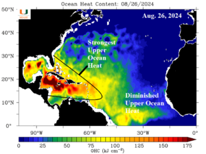
Fig. 2: The evolving and immense upper ocean heat centered on the Caribbean Sea in late August just prior to the onset of the very active late season.
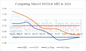
Fig. 3: Comparing the Nino34 SSTA and multivariate ENSO index in 2024.
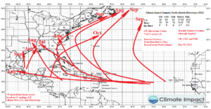
Fig. 4: May 30, 2024, Climate Impact Company prediction of an anticipated 11 hurricanes for the 2024 tropical cyclone season.
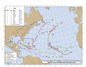
Fig. 5: The preliminary seasonal tracks analysis for the 2024 season through Oscar. 3 late season storms have yet to be added.

