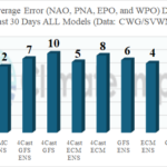
How Is AIFS Doing Vs. Other Forecast Models? Some Preliminary Results
06/26/2024, 2:56 pm EDT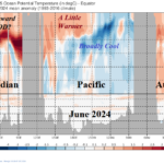
June 2024 Trend Upper 100 Meters Equatorial Global Oceans
07/08/2024, 3:56 pm EDT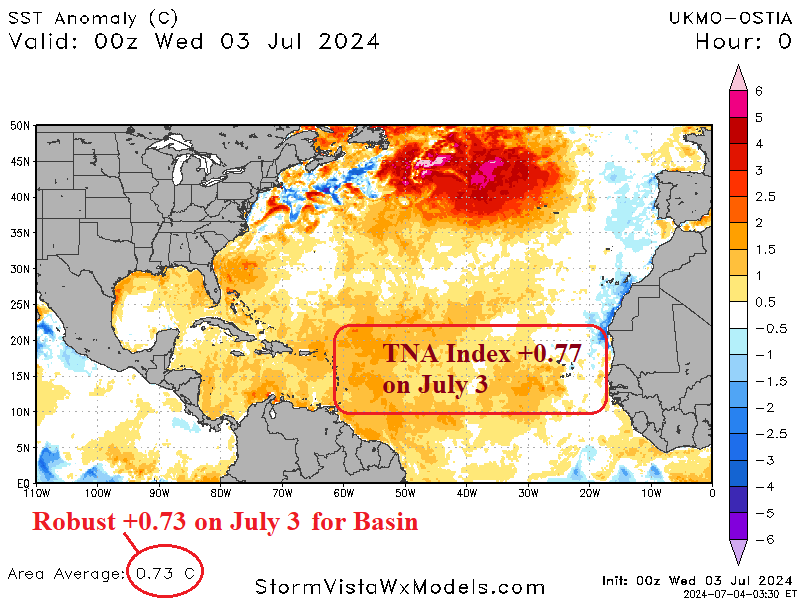
Executive summary: The Climate Impact Company North Atlantic basin seasonal activity forecast is updated. The seasonal activity forecast has increased dramatically propelled by the very warm North Atlantic basin and neutral ENSO to weak La Nina climate ahead. The activity forecast now indicates 24 tropical storms, 13 hurricanes, and 6 major hurricanes. The accumulated cyclone energy (ACE) index is revised sharply upward to 232. The ACE index projection is second highest on record, trailing only 2005 (245).
Climate discussion: Beryl is the strongest early season hurricane on record in the North Atlantic basin reaching category-5 intensity with 165 mph wind and 934 MB pressure in the eastern Caribbean Sea earlier this week. A certain contributor to this storm intensity was the 29C ocean surface temperature, nearly 1.5C warmer than normal.
Due to the persistent anomalous warmth of the North Atlantic basin, ENSO phase only inhibits tropical cyclone activity when El Nino is present. If ENSO is neutral or La Nina is present, above normal seasonal activity occurs nowadays due to the North Atlantic warmth. Despite El Nino, last year managed to produce 20 tropical storms, 7 hurricanes, and 3 intense hurricanes which is unprecedented for an El Nino year. The reason for the over-achieving seasonal activity in 2023 was the anomalous warm basin which was also the primary contributor to Beryl’s intensity.
The June 2024 Nino34 SSTA was +0.24C. No global SSTA forecast models indicate the slightly warm SSTA and instead are all slightly cool. The implication is La Nina forecasts for tropical cyclone season agreeable to most dynamic and statistical models are overstated. Climate Impact Company prefers the weaker La Nina risk for mid-to-late tropical cyclone season as forecast by ECMWF (Fig. 1). The bulk of the North Atlantic basin tropical cyclone season will occur with neutral ENSO and a steady full-throttle La Nina climate is delayed until later 2024.
The primary contributor to the updated North Atlantic basin season tropical cyclone activity forecast remains the vigorous anomalous warmth of the entire basin as defined by Atlantic multi-decadal oscillation (AMO) and in the tropics as identified by tropical North Atlantic (TNA) index (Fig. 2). Both the AMO and TNA indices were about +0.8C in June which are robust warm values and a continuation of the record warm North Atlantic of the past 2 years. Of note, is the cooling of the North Atlantic basin during the past 30 days (Fig. 3).
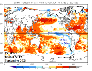
Fig. 1: The ECMWF global SSTA forecast for September 2024.
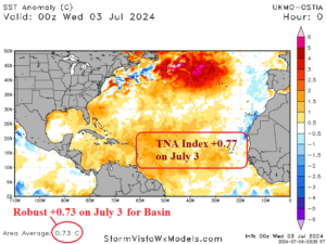
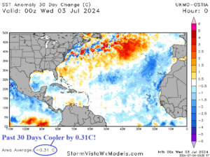
Fig. 2-3: The North Atlantic basin SSTA for July 3, 2024, and 30-day change.
Forecast bias correction: The warming North Atlantic, accelerating during recent years, has caused a consistent too low forecast bias of seasonal activity in the 1999-2023 verification scores. The calculated bias for non-El Nino years applied to the 2024 updated bias is +2.89 for tropical storms, +0.73 for hurricanes, and +0.25 for major hurricanes. Each value is added to the constructed analog calculation to produce the final forecast.
The updated seasonal forecast: The updated forecast equally considers 3 analog years (Table 1). Each analog year contained either neutral ENSO or weak La Nina as projected for the 2024 season. Each analog year produced extremely warm TNA which is present and continues in 2024. The analog years are 2017, 2005, and 1995. The updated forecast features a significant increase from 21 to 24 tropical storms, 11 to 13 hurricanes, and 5 to 6 major hurricanes. The ACE index increases dramatically from 180 to 232. The number of storms is the 3rd highest on record while the number of hurricanes and major hurricanes is tied for 2nd highest on record.
| Year (weight) | Tropical Storms | Hurricanes | Intense Hurricanes | ACE Index |
| 2017 | 17 | 10 | 6 | 225 |
| 2005 | 28 | 15 | 7 | 245 |
| 1995 | 19 | 11 | 5 | 227 |
| Average | 21.33 | 12.0 | 6.0 | 232.3 |
| Correction | 2.89 | 0.73 | 0.25 | N/A |
| Forecast | 24 | 13 | 6 | 232 |
| Previous | 21 | 11 | 5 | 180 |
| 5-Year NML | 20.6 | 8.2 | 3.6 | 139.8 |
| 15-Year NML | 16.9 | 7.6 | 3.4 | 132.8 |
| 30-Year NML | 15.5 | 7.5 | 3.4 | 130.4 |
Table 1: The CIC-CA North Atlantic basin 2024 seasonal tropical cyclone activity forecast.
Other seasonal forecasts: Tropical Storm Risk/U.K. will update their forecast on July 5th while Colorado State University updates their seasonal forecast on July 11th. Their most recent forecasts each indicate an active season ahead (Table 2). The NOAA forecast issued in May will not be updated. As of today, seasonal activity is already above normal (Table 3).
| Tropical Storms | Hurricanes | Intense Hurricanes | ACE Index | |
| CIC | 24 | 13 | 6 | 232 |
| CSU | 23 | 11 | 5 | 210 |
| TSR/UK | 24 | 12 | 6 | 226 |
| NOAA | 17-25 | 8-13 | 4-7 | N/A |
Table 2: The North Atlantic basin 2024 tropical cyclone seasonal activity forecast from Climate Impact Company, Colorado State University, Tropical Storm Risk/U.K., and NOAA/NHC.
| Tropical Storms | Hurricanes | Intense Hurricanes | ACE Index | |
| 2024 | 3 | 1 | 1 | 28.7 |
| Normal | 1.4 | 0.2 | 0.0 | 2.8 |
Table 3: North Atlantic basin real-time tropical cyclone activity in 2024 so far compared to normal for today. The adjusted North Atlantic basin seasonal tropical cyclone activity forecast includes this data.
Regional forecasts: The regional forecasts are based on monthly precipitation forecasts provided by a consensus of the constructed analog issued by Climate Impact Company, probability forecasts released by NOAA and the International Research Institute for Climate and Society, and monthly operational models including ECMWF and CFS V2.
Texas: Beryl will have major impacts on Texas early next week. Wet weather related to residual moisture associated with Beryl lingers through mid-July. Based on ECMWF “weeklies” additional tropical cyclone threats exist for late July and especially the first third of August. The remainder of August also looks threatening. The most active part of the season is the next 8 weeks and hurricane coastal strikes are included. The consensus of forecasts beginning with September and into later autumn is tropical cyclone risk shifts eastward away from Texas.
Louisiana: A wet weather period is forecast for the last full week of July which may include a tropical cyclone risk. If so, the issue is locally generated and not a long-distance traveler. According to ECMWF “weeklies” there is risk of a significant tropical cyclone the week of August 5-12. Regarding the remainder of August and September, the risk of a coastal strike of a hurricane in Louisiana is the highest for the entire U.S. Coast during this time. More than one hurricane is possible during this time. Tropical cyclone activity abates after September.
Northeast Gulf/West Coast Florida: Tropical cyclone risk increases during the last third of July. ECMWF “weeklies” indicate risk is highest during the week of July 22-29 and August 5-12. The events of concern generate in the tropical North Atlantic and travel to this region suggesting hurricanes are more likely. This region is very active the remainder of August and September. However, the primary tracks may be across Florida and into the Northeast Gulf rather than south-to-north across the eastern Gulf.
East Coast of Florida: The highest risk of impacts to tropical cyclones this season is in Louisiana, followed closely by Texas for the first half of the season, and third by the East Coast of Florida. This zone is affected by storms that generate in the Bahamas and long-distance travelers out of the deep tropics biased toward August and September.
Southeast Coast: Probability forecasts implicate Florida, Georgia, and South Carolina for above normal risk of coastal impacts from tropical cyclones in AUG/SEP/OCT. During this time, several events threaten this region including more than 1 hurricane. The ECMWF “weeklies” indicate a short-term tropical cyclone risk centered on July 22-29.
Mid-Atlantic: ECMWF “weeklies” are not forecasting significant tropical cyclone risk for this region through mid-August. However, all operational climate forecasts indicate the second half of August and September offer above normal risk of impacts from land-falling tropical cyclones. At least one hurricane is expected to make landfall during this time. After September, the risk of tropical cyclones decreases dramatically.
Northeast Coast: The risk of a coastal strike by a significant tropical cyclone is above normal and centered on August. The anomalous warm SSTA off the Northeast Coast implies storms moving northward maintain intensity longer than normal.