North Atlantic Tropical Season Gaining Storms Fast; Very Warm Oceans Helping
10/10/2024, 12:49 pm EDTExplaining The Recent Spike in Negative Phase Indian Ocean Dipole
10/16/2024, 8:52 am EDT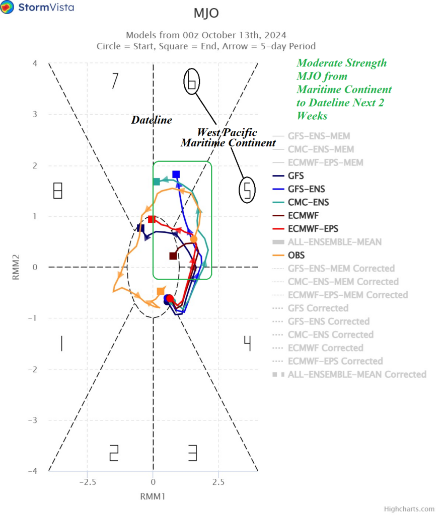
Highlight: Moderate MJO triggers +GLAAM.
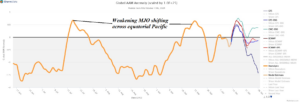
Fig. 1: The 15-day forecast of global atmospheric angular momentum utilizing all models and the 120-day history identifying 2 recent positive spikes.
Discussion: Utilizing all forecast models, a spike in positive phase global atmospheric angular momentum (GLAAM) is predicted through the next week or so followed by return of the negative phase (Fig. 1). +GLAAM is generally associated with stronger than normal westerly jet streams in the middle latitudes. During the past 120 days, two +GLAAM spikes were observed each forming after an eastward shifting Madden Julian oscillation (MJO) weakened entering cooler waters east of the Dateline. The latent heat release of the weakening convection associated with the MJO was transported poleward to increase mid-latitude baroclinicity causing faster winds. The 2-week MJO forecast reveals a moderate strength episode shifting from Maritime Continent toward the Dateline (Fig. 2). Weakening is likely to occur after the 2-week period once MJO shifts to the cooler eastern equatorial Pacific. Implied is the +GLAAM in the 7-day forecast may last longer. Additionally, +GLAAM is (also) powered by positive phase mountain torque generated over the South Asia Mountains. The global wind oscillation (GWO) forecast indicates GWO Phase_5 is present in the 2-week outlook suggesting a lengthier +GLAAM regime than forecast (Fig. 3). Faster mid-latitude flow should lead to a stronger polar vortex. The arctic oscillation (AO) shifts to the sharp positive phase in the 6-10-day period (Fig. 4) and the polar vortex is vividly projected by AIFS at that time (Fig. 5). The 500 MB heights in the middle latitudes are biased warm (above normal) due to the influence of war sea surface temperature anomalies (SSTA) across the middle latitudes (Fig. 6).
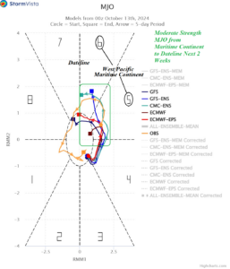
Fig. 2: The 2-week Madden Julian oscillation forecast utilizing all models indicates moderate intensity shift across the western half of the equatorial Pacific.
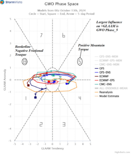
Fig. 3: The 2-week global wind oscillation forecast indicates the strongest influence on positive phase global atmospheric angular momentum (phase_5) is present.
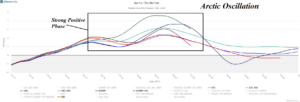
Fig. 4: The 2-week arctic oscillation outlook utilizing all models. Strong positive phase suggests a strong polar vortex.
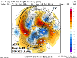
Fig. 5: AIFS northern hemisphere 500 MB anomaly forecast for the 6-10-day period across the northern hemisphere.
Fig. 6: Daily global SSTA analysis identifies the (record) warm SSTA across the northern hemisphere oceans.