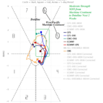
Moderate Madden Julian Oscillation Triggers Increased Global Atmospheric Angular Momentum
10/13/2024, 10:42 am EDT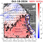
Record Strength and Length of -PDO Regime Despite Warm Northeast Pacific!
10/21/2024, 5:37 am EDTDaily IOD Index: -0.68 (ADJUSTED by UK MET)
Daily Nino34: -0.47 (-0.55 one week ago)
Charts of the day: Explaining sudden -IOD and 10-day rainfall forecast.
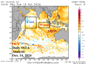
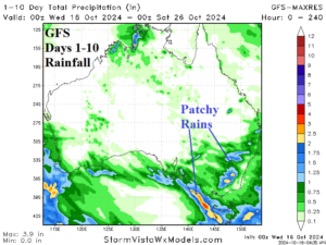
Discussion: The recent reversal in the IOD pattern to negative phase is quick and sharp. Climate Impact Company explains this sudden change due to expansion of a marine heat wave off the northwest coast of Australia into the eastern Indian Ocean tropics. Some dynamic models maintain this trend, others prefer this sudden shift as temporary. The -IOD pattern may continue if La Nina develops. However, full throttle La Nina onset appears delayed and may not happen. The 10-day rainfall outlook across Australia according to GFS indicates some patchy moderate rains across Interior New South Wales.
Week-2 Ahead Forecast valid October 27-November 2, 2024: Dry and hot most of continent.
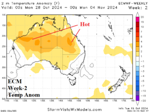
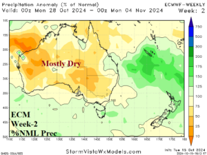
Discussion: Upper ridge extends across the marine heat wave northwest of Australia to Central Australia inspiring anomalous heat and dryness for most of the continent.
Week-3 Ahead Forecast valid November 3-9, 2024: Turning wetter.
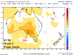
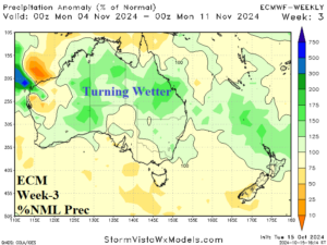
Discussion: An amplified upper ridge emerges south of Australia. The Northwest Australia ridge reverses to a weak trough. A wetter pattern change emerges.
Week-4 Ahead Forecast valid November 10-16, 2024: Widening wet weather.
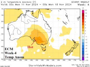
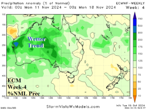
Discussion: The upper ridge shifts to Tasmania eastward to New Zealand while an upper low cuts off over Southwest Australia. The upper low invites the wetter trend to continue although East-south Coastal Australia stays hot.