News
12/08/2025, 4:30 am EST
A map of a storm AI-generated content may be incorrect.

Excessive Rainfall Forecast by ECM Central/East-central South America.

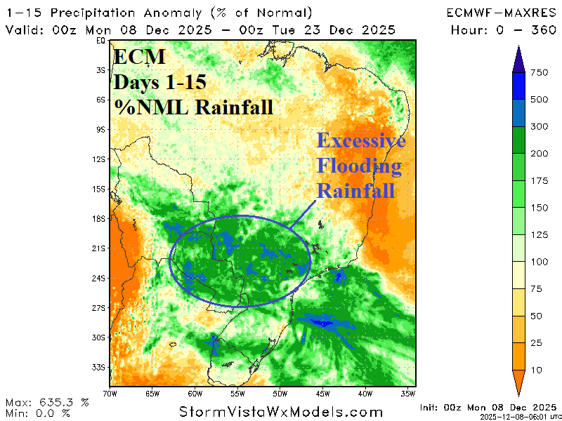
ECM indicates potential for flooding rainfall during the middle third of December across Eastern Bolivia, Paraguay, and Southwest/Southeast Brazil. The rain may abate in the 11-15-day period. The 24-hour change indicates a significant increase in rainfall for Paraguay and eastward. The culprit is an intensifying upper trough extending from east of Argentina northwestward into Brazil during much of the next 2 weeks.
12/07/2025, 2:50 pm EST
A graph showing the weather forecasts AI-generated content may be incorrect.

In U.S. Climate Signals Support Colder West/Warmer East Extended-range

Climate signals forecasts identify provide clues as to where the weather pattern is heading after mid-December. The West Pacific oscillation (WPO) and Pacific North America (PNA) index is negative after mid-December supporting a shift and expansion of the cold pattern over western North America. Negative East Pacific oscillation (-EPO) spikes in one week as another “polar vortex” cold outbreak strikes the U.S. The North Atlantic oscillation (NAO) aggressively shifts to positive phase during the medium range supporting an eastern North America warm-up and validating the -WPO/-PNA colder support in the West. The question is whether -NAO warmth can eat away at the snow cover validating very warm 11-15-day forecasts by ECM.
12/02/2025, 1:11 pm EST
A graph of different colored lines AI-generated content may be incorrect.

Is La Nina Starting to End?

Last week, the NINO SSTA regions warmed including the Nino 4 (near the Dateline) and Nino12 (northwest coast of South America) where sea surface temperature anomalies (SSTA) shifted to neutral phase. The Nino34 SSTA barely remains within the La Nina threshold. The warming is likely due to weakening trade winds slowing the upwelling of cool water process.