News
12/15/2025, 4:07 pm EST

At The Surface, La Nina Strengthened Last Week. However, Subsurface Cool Fuel Diminishing.

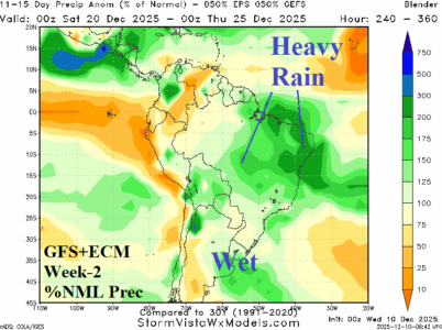
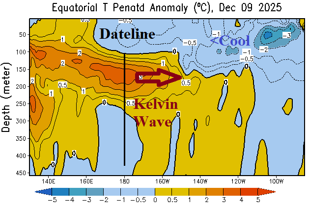
During the past week, the Nino34 and Nino3 sea surface temperature anomaly (SSTA) regions across the east-central and east equatorial Pacific Ocean cooled to the second strongest level of the weak late 2026 La Nina episode. The central equatorial Pacific and off the northwest coast of South America are near normal. Of interest is the appearance of a Kelvin Wave shifting east of the Dateline during early December.
12/12/2025, 9:53 am EST

Cold Retreat to Canada; New York/New England at Risk of Returning Cold Late December

The intense Pacific “atmospheric river” storm track across California to the Great Basin is releasing mild maritime air eastward of the Continental Divide extending anomalous warmth to the Atlantic Seaboard. Canada is very cold, and the attendant chill should extend southward across snow cover. New York and New England are at risk of "sneaky cold" late December.
12/11/2025, 8:33 am EST

Next Arctic Air Mass Forms in Western Russia; Threat to Europe?

Lack of snow cover is helping to propel a mild climate across Europe. However, a colder change may be on the way in the extended range. Stratospheric warming propelling an arctic air mass in Canada and into the East U.S. during early December shifts westward to Asia during the next 2-3 weeks. The emerging stratospheric warming over Asia will cause a cold air mass to initiate across Northern Asia into early next week.
12/10/2025, 3:38 am EST
A map of the weather AI-generated content may be incorrect.

MJO-Inspired Heavy Rain for Brazil, Once Effect Fades, Brazil Drier into New Year

The wet weather pattern has shifted to Brazil during early December. Heavy rain was observed across Northern Chile to northwestern Argentina during the past week. The 10-day outlook equally combining GFS and ECM reveals wet weather shifts to Paraguay and eastward. Recently developed dryness in Argentina continues.