Emerging Marine Heat Wave Leads to “Highest Heat Warning Possible” in Beijing
06/23/2023, 8:56 am EDTCause Of The Wet Pattern Change in the Midwest U.S.
06/29/2023, 4:56 am EDT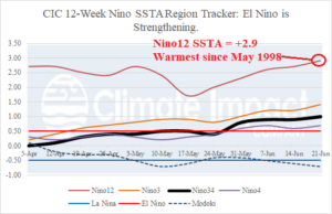
Fig. 1: The 12-week Nino SSTA observations indicate steady strengthening of El Nino. Note that the Nino12 region (off the northwest coast of South America) is the warmest since May of 1998.
Discussion: The Nino34 SSTA region in the east-central equatorial Pacific Ocean shifted warmer last week to +1.00 as El Nino steadily strengthens and approaches moderate intensity (Fig. 1). Waters off the northwest coast of South America (Nino12 region) are the warmest since May 1998 which along with 1982 and 2015 marked the strongest El Nino on record. In the equatorial Pacific subsurface, upper ocean heat to support El Nino development has increased sharply during MAY/JUN and is now spreading westward (Fig. 2). The westward spreading of subsurface warmth indicates additional El Nino strengthening continues, waters near the Dateline will warm, and an El Nino climate will develop over the next 1-2 months. The response of the warming equatorial East Pacific is appearing in the southern oscillation index (SOI) which shifted to the El Nino-like negative phase in May (Fig. 3). To complete the flip of global climate away from the 202-23 La Nina category and into El Nino, a 3rd consecutive month of -SOI is needed.
Fig. 2: Subsurface equatorial Pacific Ocean upper heat anomalies for the past year indicates warming in the East Pacific to support El Nino is advancing westward.

Fig. 3: Southern oscillation index has flipped to negative phase for 2 consecutive months and after a third should shift the global climate into El Nino.