Cause of The Expanding May 2023 U.S. Drought
06/02/2023, 8:13 am EDTWet Trade Winds to Develop Across Record Warm SSTA (for June)
06/13/2023, 8:44 am EDT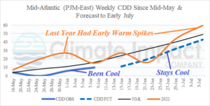
Fig. 1: Mid-Atlantic population weight CDD on a weekly basis observed by NOAA through last week and projected by Climate Impact Company through July 6th.
Discussion: Early season cooling demand in the Mid-Atlantic region (PJM-East) has been nearly non-existent during mid-to-late May and the first half of June (Fig. 1) and Climate Impact Company expects the below normal trend to continue into at least early July. There are no weeks from late May to early July when Mid-Atlantic CDD reaches or exceeds normal. Last year, the weekly CDD pattern was variable and featured two warm spikes from late May to early July.
The cool start to the warm season is this high demand for electricity region is caused by the westward shift of the 2014-2023 North Atlantic warm hole (NAWH) from a semi-permanent location stretching from the Labrador Sea to south of Greenland to just-off the Mid-Atlantic/Northeast U.S. (Fig. 2). The NAWH is caused by the stratification of the upper layer of the ocean by cool fresh water pushed southward by the Labrador Current following spring snow and ice melt from Northeast Canada and Greenland. The NAWH pattern has become stronger and semi-permanent since 2014.
During the past 2 weeks, the NAWH pattern appears to be strengthening as waters off the entire East Coast have cooled (Fig. 3). Note that the Gulf Stream is vividly discernable running through the NAWH regime.
The NAWH pattern is followed due to the attendant cooling of the atmosphere aloft where an upper trough persists. Since evolution of the NAWH pattern after mid-spring a cool upper trough has dropped anchor on the U.S. East Coast (Fig. 4). All the East U.S. Coast has observed a somewhat cooler than normal start to the 2023 warm season (Fig. 5).
Until the waters off the East Coast warm significantly, the tendency for cool temperatures in the East U.S. with very limited number of warm-to-hot days will continue into mid-summer. Global SSTA forecast models are warming the waters off the East Coast. However, the 7-day, 14-day, and 30-day SSTA trend is a cooler ocean surface trend for the western North Atlantic basin. Caution is recommended for any warm forecasts into the East especially during the medium/extended range by various operational models.
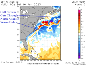
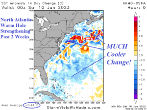
Fig. 2-3: The western North Atlantic basin daily SSTA analysis and 2-week change.
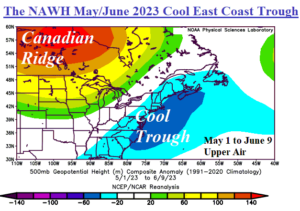
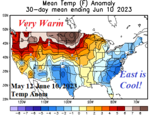
Fig. 4-5: The East U.S. upper air pattern since May 1 and attendant cool temperatures along the East Coast States.